
A'vanning in the Flinders Ranges & the Grampians
"We can go for three weeks - no more! I cannot leave my garden for more than three weeks in spring."
And so, the boundaries were set! We would travel to Wilpena in the Flinders Ranges National Park and return via The Grampians and Bright in the Victorian High Country.
26 - 27 August 2002 -
Griffith,
NSW
 A comfortable 375 Km drive from our Canberr
suburb to Griffith - much of it along the appropriately named
Burley Griffin Way . Having won
the competition for the design of Canberra, Burley
Griffin was also given the task of designing the then growing new towns
of Griffith and Leeton . As Griffith is inside the Fruit Fly Exclusion
Zone, we were unable to carry any fruit or vegetables with us and had to shop for
these on our arrival . Unlike when entering South Australia however,
this regulation does not appear to be rigorously policed on this route.
A comfortable 375 Km drive from our Canberr
suburb to Griffith - much of it along the appropriately named
Burley Griffin Way . Having won
the competition for the design of Canberra, Burley
Griffin was also given the task of designing the then growing new towns
of Griffith and Leeton . As Griffith is inside the Fruit Fly Exclusion
Zone, we were unable to carry any fruit or vegetables with us and had to shop for
these on our arrival . Unlike when entering South Australia however,
this regulation does not appear to be rigorously policed on this route.
Our two night stay at the Griffith Caravan Village gave us ample time to gather provisions in the town and a full day to explore. The van park was clean and comfortable with plenty piping hot water, but there was very little outside lighting at night. This, together with the keypad locks on the amenities doors requiring entry of four numbers in the right sequence, meant that a visit to the amenities at night could not be a rushed affair!
Being almost completely encircled by open irrigation canals, Griffith provides much of the country's horticultural and agricultural produce and is a good base for The Riverina Wine Trail. Fresh local produce can be purchased from roadside kiosks operating on the honesty basis ($2 for a (at least 3 Kg) bag of delicious and juicy navel oranges) reminded us of how really fresh fruit tastes compared with what we purchase in the cities.
The only "hill" in the district, appropriately named Scenic Hill, lies on the northern edge of the town. A well marked 12 Km walking track has been constructed, with various lookouts along the track providing sweeping views over the Murrumbidgee Irrigation Area. Of particular interest, the track passes through the Hermit's Cave area where an Italian migrant Valerio Reccitty lived between 1929 and 1939. During this time Valerio built and decorated a variety of living areas in the caves, a chapel, and a series of terraces & gardens on the hillside where he grew his carefully tended crops.
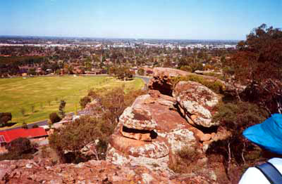
Overlooking Griffith from Scenic Hill
Walk
Griffith presents as a clean and pleasant town and, despite the current drought conditions in the area, has an air of prosperity.
28 August 2002 -
Cobar, NSW
(overnight stop)
 The 355 Km Kidman Way drive from Griffith
to Cobar was not the most attractive part of our trip. Particularly during
severe drought, the flat featureless terrain was littered with a phenomenal amount
of "road kill", mainly kangaroos, but also on this stretch, emus and the occasional
wombat. Animals grazing on what appeared to be just dust were little more
than skin and bones - only the (wild?) goats, which were in surprisingly
large numbers, appeared to be thriving in those conditions. Throughout the
journey there was a feeling of complete isolation. This is definitely not
the place to run out of fuel or breakdown through lack of maintenance!
The 355 Km Kidman Way drive from Griffith
to Cobar was not the most attractive part of our trip. Particularly during
severe drought, the flat featureless terrain was littered with a phenomenal amount
of "road kill", mainly kangaroos, but also on this stretch, emus and the occasional
wombat. Animals grazing on what appeared to be just dust were little more
than skin and bones - only the (wild?) goats, which were in surprisingly
large numbers, appeared to be thriving in those conditions. Throughout the
journey there was a feeling of complete isolation. This is definitely not
the place to run out of fuel or breakdown through lack of maintenance!
Cobar Caravan Park, 1 Km West of town on the Barrier Highway can really claim to be the "Oasis in the Desert". The shady grassy sites being the only green we had seen since leaving Griffith - it really was a welcome sight! This is a well managed park with the facilities in good repair - which is just as well since it appears to be the only caravan park for hundreds of kilometres in each direction. By mid afternoon the masses began to arrive and it quickly filled to capacity.
29 - 31 August 2002 -
Broken Hill,
NSW
 The 450 Km stretch of Barrier Highway
between Cobar and Broken Hill was far more enjoyable than that of the previous day.
With a good tail wind, the Forester/Sportliner was eager to get away from
the harsh red dust, and as the kilometres sped by, the scenery, ever so slowly,
took on just a hint of green! Wilcannia
, which is just over half way to Broken Hill, is a convenient point
to take on fuel. There is little other opportunity in either direction.
The 450 Km stretch of Barrier Highway
between Cobar and Broken Hill was far more enjoyable than that of the previous day.
With a good tail wind, the Forester/Sportliner was eager to get away from
the harsh red dust, and as the kilometres sped by, the scenery, ever so slowly,
took on just a hint of green! Wilcannia
, which is just over half way to Broken Hill, is a convenient point
to take on fuel. There is little other opportunity in either direction.
A three night stay at Broken Hill City Caravan Park gave us two clear days to explore the city and the surrounding district. This park has a few good grassy sites but most are just gravel. The roadways throughout the park are also gravel, so the whole area would be very dusty in windy weather. In other respects the park provided all we needed. In our experience throughout the trip, if you book ahead you are far more likely to be given a "good" site than if you just turn up unannounced!
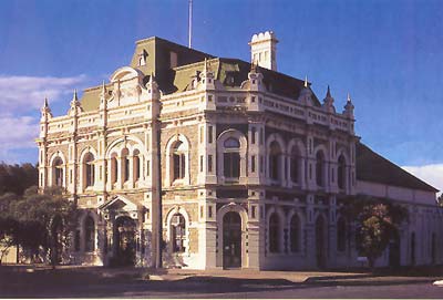
To learn something of the history of Broken Hill we went on a volunteer guided two hour "Town Walk". Our guide (Margo) was very knowledgeable about the history of her native city, and her enthusiasm was infectious! After an introductory video in the Visitor Information Centre we were taken around to see the actual places which were pivotal in the growth of the city. Broken Hill being a mining town from the beginning, it's history and growth was also that of the Trade Union movement. Even the streets have chemical element names, many of which would have been mined in the district. Of particular interest was the magnificent Trades Hall built in 1889. In one of the rooms there is a portrait collection of all the Prime Ministers of Australia since federation. What is different however is that all the portraits use crushed aggregate of various colours to capture the likeness of each PM, which is phenomenal!
Broken Hill Trades Hall
Well worth the visit was the Flying Doctor base where we were able to see the base at work, watch a video covering much of it's operation, and visit the museum. Having driven through just a small portion of the outback, it is easy to understand why the Royal Flying Doctor Service is such a godsend to people living in these isolated areas.
The Line of Lode Miner's Memorial, prominently located on the "line of lode" overlooking the city, is a recent addition to the skyline. It commemorates the lives of those miners lost since the start of mining in 1885.
Approximately 12 Km from the city centre lies the appropriately named Living Desert, through which there is a beautiful well defined walking trail with interpretive signs describing the subtlety of the region. The 10 Km trail loop passes through the Sculpture Site.
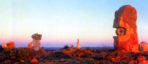
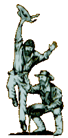
Sculpture Symposium in Living Desert Area
Standing sentinel encircling the hilltop, the imported sandstone blocks, each weighing many tonnes, were carved into their mysterious shapes by a team of sculptors from many parts of the world in 1993 as part of a Sculpture Symposium. A visit during sunrise or sunset is unforgettable!
1 - 4 September 2002 -
Wilpena,
S.A.
The 520 Km trip between Broken Hill and the Flinders Ranges National Park via Quorn and Hawker (to avoid the partially unsealed road between Orroroo and Hawker) passed without incident other than the compulsory stop at the Fruit Fly Inspection Station at Oodla-Wirra, where we were interrogated to the nth degree! The South Australian authorities are certainly more vigilant in this regard than their NSW or Victorian counterparts. Again, the further west we travelled the greener and more prosperous looking the countryside became.
 On the advice of other A'vanners we stayed at
Rawnsley Park Station
in preference to
Wilpena Pound Camping &
Caravan Park. Rawnsley Park is 21 Km south of Wilpena whereas
the Wilpena Pound park lies in the heart of the Pound itself. The Rawnsley
park has a few grassy sites around a central lawn area, but the majority of sites
were gravel based. Again, we were lucky enough (because we booked in advance?)
to have a lightly shaded grassy site. The ease with which a Sportliner can be "person" handled to make most of the view
was put to good use!
On the advice of other A'vanners we stayed at
Rawnsley Park Station
in preference to
Wilpena Pound Camping &
Caravan Park. Rawnsley Park is 21 Km south of Wilpena whereas
the Wilpena Pound park lies in the heart of the Pound itself. The Rawnsley
park has a few grassy sites around a central lawn area, but the majority of sites
were gravel based. Again, we were lucky enough (because we booked in advance?)
to have a lightly shaded grassy site. The ease with which a Sportliner can be "person" handled to make most of the view
was put to good use!
The bushwalks around Rawnsley Park, in our opinion, are even more spectacular than those within the "Pound" itself. With a choice of seven well marked walking trails, ranging from 1/2 hour to 5 hours return, we finished up by doing them all! Particularly impressive was the walk to Rawnsley Bluff which provided excellent views down into the central part of Wilpena Pound, and further on, views over the Chace Ranges.
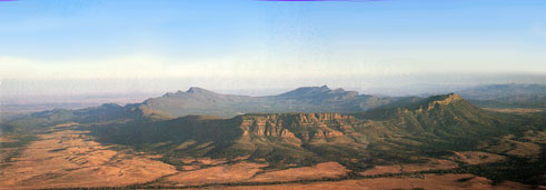
Wilpena Pound from the air
An easy 45 minute return walk from the park to Alison Saddle to view the Elder Ranges at sunrise and Rawnsley Bluff at sunset is a must. The colours of the escarpments at those times are "out of this world"!
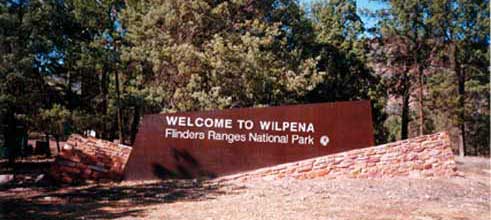
Entry to Wilpena Pound and Visitor Centre
![]() If bushwalking is your "thing", you are
"spoilt for choice" within Wilpena Pound. With a network of sixteen interconnected walking trails ranging from "easy",
through "moderate" to "difficult" there really is something for everyone.
And with colour coded route marker posts
such as these, even the Thomas' had no excuse for getting lost!
If bushwalking is your "thing", you are
"spoilt for choice" within Wilpena Pound. With a network of sixteen interconnected walking trails ranging from "easy",
through "moderate" to "difficult" there really is something for everyone.
And with colour coded route marker posts
such as these, even the Thomas' had no excuse for getting lost!
Of course, no visit to the outback would be complete without a dust storm, and we were not to be disappointed! On the second day of our visit the heavens turned dark brown, the wind gust intensity increased, and in no time at all everything was covered with red dust, after which it promptly rained sufficiently to turn it all into red mud pies! If ever there was a time to "Not Let Your Friends Use Canvas" this was it! This was seen of course as part of the thrill of being in the outback. Little were we to know that 6 weeks later, back in our "tame" Canberra suburb we would wake one morning to find the outback had caught up with us, with a layer of the now familiar red dust coating everything!
5 September 2002 - Mount Barker,
S.A. (overnight stop)
 With over 900 Km between Rawnsley Park and the Grampians, we decided to stop
off at Mount Barker Caravan & Tourist Park, which lies
about half way between the two, and by which time the countryside was rich and
green once more. Now, this park boasts "
nice shady sites" which is true, especially if you are happy to park
beneath huge pine trees having branches which would totally flatten your A'van if
they decided to let go in the decidedly gusty conditions at the time. This,
plus being sandwiched between two of the largest
Winnebargo Motorhomes, each with underside lockers which could easily
accommodate the Sportliner, gave us a distinctly claustrophobic feeling!
In other respects the park was adequate, but the large number of long-term vans
gave it a decidedly unsavoury look.
With over 900 Km between Rawnsley Park and the Grampians, we decided to stop
off at Mount Barker Caravan & Tourist Park, which lies
about half way between the two, and by which time the countryside was rich and
green once more. Now, this park boasts "
nice shady sites" which is true, especially if you are happy to park
beneath huge pine trees having branches which would totally flatten your A'van if
they decided to let go in the decidedly gusty conditions at the time. This,
plus being sandwiched between two of the largest
Winnebargo Motorhomes, each with underside lockers which could easily
accommodate the Sportliner, gave us a distinctly claustrophobic feeling!
In other respects the park was adequate, but the large number of long-term vans
gave it a decidedly unsavoury look.
As we had seen much of the beautiful Adelaide Hills when at Nuriootpa 3 months earlier, we stayed just the one night.
6 - 9 September 2002 - The
Grampians, Victoria
Situated at the end of the Great Dividing Range , the rugged mountain ranges comprising the Grampians rise spectacularly from the otherwise flat countryside surrounding it, and is without doubt one of Victoria's finest National Parks.
 Our home for the next four nights was to be the Big-4 Parkgate Resort
at Halls Gap, right in the heart of
Wonderland which is the most popular part of the Grampians.
We have stayed at this park before, and were happy to return as it is an excellent
example of what a tourist park can be. Additionally, a large hall makes it particularly suitable for club gatherings.
The only matter of concern during our stay was the number of people
wandering around at all times of the day brandishing swords of all descriptions.
Other than the surprise however, they appeared harmless (or so we hoped)!
But it was not until the park manager told us they were part of a Marshall Arts gathering did we really feel at
ease again!
Our home for the next four nights was to be the Big-4 Parkgate Resort
at Halls Gap, right in the heart of
Wonderland which is the most popular part of the Grampians.
We have stayed at this park before, and were happy to return as it is an excellent
example of what a tourist park can be. Additionally, a large hall makes it particularly suitable for club gatherings.
The only matter of concern during our stay was the number of people
wandering around at all times of the day brandishing swords of all descriptions.
Other than the surprise however, they appeared harmless (or so we hoped)!
But it was not until the park manager told us they were part of a Marshall Arts gathering did we really feel at
ease again!
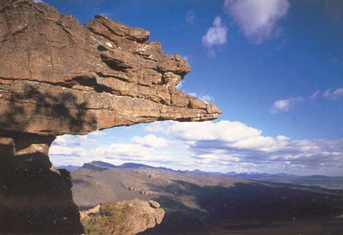
The Balconies (Jaws of Death) Lookout providing panoramic
views over the Victoria Valley
Once again we were spoiled for choice when it came to bushwalks. With 25 walks in the Wonderland area alone we could have stayed at least a couple of weeks and not had to retrace our steps. All the walks we actually did were well marked, and the Walks Maps available from the National Park Centre (2.5 Km south of Halls Gap) are well worth the few dollars they cost. The three maps cover walks in the Northern, Southern and Wonderland parts of the Grampians. They are on good quality "glossy" paper which does not disintegrate if it gets wet, and are great for planning your day whilst breakfasting!
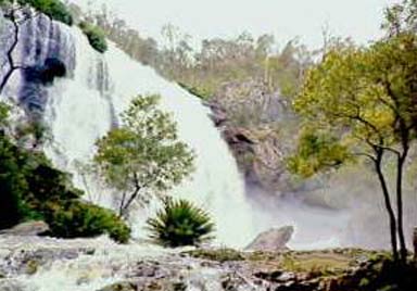
MacKenzie Falls, largest and most impressive waterfall
in the Grampians
Adjacent to the National Park Centre, the Brambuk Aboriginal Cultural Centre is a most impressive source of information on Aboriginal cultural heritage and the local rock art sites, all housed in a building uniquely sympathetic to its surroundings - don't miss it!
Despite the weather being wet and windy, we thoroughly enjoyed our stay in
the Grampians, and once again made the promise that
we'll be back!
10 - 12 September 2002 - Ballarat,
Victoria
 Home for the next three nights was the Big-4
Ballarat Goldfields
Holiday Park, conveniently located within walking distance of
Ballarat's major attractions -
Sovereign Hill and the Gold Museum
. Catering exclusively for the traveller, it has no permanent living which can so often detract from an otherwise
appealing caravan park. Most sites have
lightly shaded grass with a concrete pad for the awning area.
Our site also had a separate concrete slab for parking the car! With an
indoor camp kitchen and enclosed eating/meeting area, it would be quite
suitable for club gatherings. It even has an
Internet Kiosk for those who cannot possibly exist without checking for
e-mails!
Home for the next three nights was the Big-4
Ballarat Goldfields
Holiday Park, conveniently located within walking distance of
Ballarat's major attractions -
Sovereign Hill and the Gold Museum
. Catering exclusively for the traveller, it has no permanent living which can so often detract from an otherwise
appealing caravan park. Most sites have
lightly shaded grass with a concrete pad for the awning area.
Our site also had a separate concrete slab for parking the car! With an
indoor camp kitchen and enclosed eating/meeting area, it would be quite
suitable for club gatherings. It even has an
Internet Kiosk for those who cannot possibly exist without checking for
e-mails!
Set aside a full day to see Sovereign Hill. With so much to see and do, the history of the claimed richest alluvial goldfields in the world, really does come alive! And if you still thirst for more, return at sunset for the sound-and-light show which re-creates the Eureka Rebellion.
Directly opposite Sovereign Hill is the Gold Museum (our ticket covered entry to both venues). The impressive building and presentations really exceeded our expectations. The museum displayed far more than just gold nuggets, alluvial deposits, ornaments and coins! A series of galleries held fascinating exhibits from it's extensive historical collection - not to be missed!
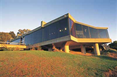
Sovereign Hill Gold Museum
13 - 14 September 2002 - Bright,
Victoria
Last but not least was picturesque Bright, where the vegetation was lush and green, and cattle grazing contentedly in the fields were in excellent condition - so different from those we had seen earlier in the trip. With blue skies, green grass and the snow covered distant mountains it really was magic!
 Home for our last two nights of the trip was
Pine Valley Top Tourist Park
(no permanents), conveniently located at the edge of town and
within walking distance of all that Bright has to offer. Nice grassy sites
with concrete pads but at the time of year we were there (spring), the "shade trees"
kept dropping "bits" all over the van and car. Well equipped covered camp
kitchen and a good eating / meeting room. The park provided all we needed
and is an excellent base for exploring the area.
Home for our last two nights of the trip was
Pine Valley Top Tourist Park
(no permanents), conveniently located at the edge of town and
within walking distance of all that Bright has to offer. Nice grassy sites
with concrete pads but at the time of year we were there (spring), the "shade trees"
kept dropping "bits" all over the van and car. Well equipped covered camp
kitchen and a good eating / meeting room. The park provided all we needed
and is an excellent base for exploring the area.
As always, our first port of call was the Visitor Information Centre where we picked up brochures on local bushwalks and also details of the Rail Trail which currently terminates in Bright.
We were delighted to find there are 8 well defined walks through the hidden valleys and alongside the crystal clear rivers, all of which are part of Bright's Alpine Setting! There are many lookouts along the way, giving spectacular views of the surrounding area.

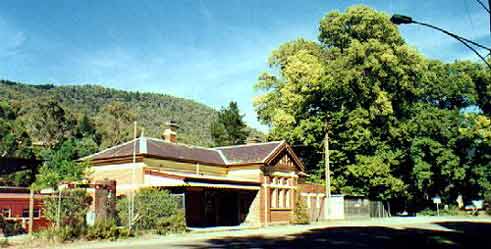
Bright Station - Terminus of the "Murray
to the Mountains" Cycle Rail Trail
15 September 2002 - Journey Home
The 620 Km trip home via Tumut (spectacular view of Mount Beauty from the lookout just before Tawonga) was without incident, and on arrival home - guess what - the garden looked just as it did when we left three weeks earlier!
Trip Statistics:
Car distance travelled: 4,200 Km
A'van distance travelled: 3,780 Km
Bikes distance each travelled: 58 Km
Bushwalks each travelled: 123 Km
A'van problems: Nil
Keith and Pam Thomas (October 2002)
E-mail: emrysthomas2024@gmail.com
Website URL "actavanning.org/index.html"