The Pilbara - Western Australia
August - October 2005
By: Dennis & Joan Thornton
Following our recent house invasion, it was with some trepidation that we left our home for over nine weeks touring the goldfields and Pilbara areas of Western Australia. Our proposed route was across the Nullarbor to Kalgoorlie, north to Leinster and then west to Sandstone and Mt Magnet. Again north as far as Marble Bar and then head towards the WA coast at Port Hedland. From there a leisurely trip south towards Perth returning in time for the Junee ACT Region A'vanner's meeting.
In the first four days we covered 3,026 Km, averaging 756.5 Km per day before stopping at Norseman. This distance was quite remarkable as we spent considerable time at the Nundroo Roadhouse on the third day after catching up with the Channel 9 Coles Variety bash vehicles who were entertaining the local aboriginal children. They were travelling from Victor Harbour (SA) to Perth in 5 days. Rain started at the SA/WA border.
Overnight the rains finally stopped at Norseman & all caravan owners were complaining about the considerable condensation in their vans, it was literally dropping from the walls and ceiling. TV & radio announcements warn of severe inland storms making roads impassable.
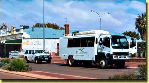
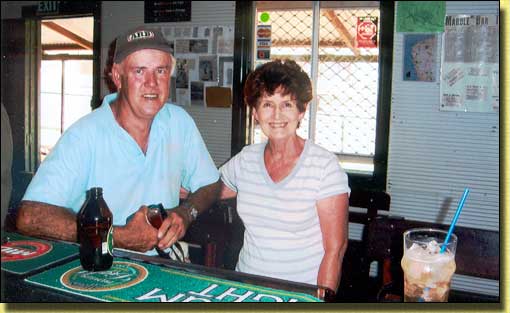
In Kalgoorlie we got our Miners Right, and changed from winter to summer gear. The KCGM Gold Mine Super Pit is a massive size. We saw it 5 years ago and its now twice the size. KCGM say that when it is finally excavated the massive hole will be seen from the moon. At Boulder we were disappointed to find out that the Loopline Railway had closed its operations in 2004, because the Super Pit had swallowed its tracks. Whilst in the supermarket, we got the first one of regular weekly calls from The Greenwoods, and they invariably found us in supermarkets!
4WD & A'van at Leonora
In front of us was a REAL 4WD for off road travel - full of old timers,
whose legs were hardly able to climb the steps to get in!
It was only when we started travelling north towards Menzies & Leonora did we realise how much rain had fallen in the area. Approaching Sandstone we noticed the considerable amount of water on the nearby land and worried about driving off-road. The facilities at the isolated Sandstone CP would put many city/country CP's to shame.
Sandstone is a town which started life as a boom gold rush town in the late 1890s and had become a virtual ghost town by the end of World War 1. nbsp; Today it is a service centre for the surrounding large pastoral holdings. There are many historical sites in the area and the Sandstone Heritage Trail has, for example, a brewery, state battery with original stampers and London Bridge formed of weathered basalt and believed to be about 350 million years old.
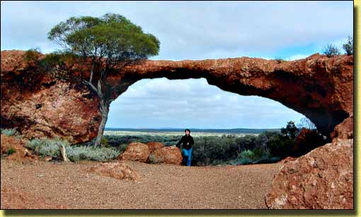
London Bridge at Sandstone, with Joan, to give some idea of the arch height
As we progressed around the Pilbara some officials were indifferent towards metal detecting, whilst other areas were inaccessible - case in point was Mt Magnet. Mines Office was closed but it did state 'Please do not conduct prospecting activities on any Mt Magnet gold mining leases' - and leases were everywhere. We decided to transverse the Mt Magnet Tourist Trail instead. Amongst many of the attractions was the Amphitheatre which is a unique breakaway surrounded by saltbush and mulga plains. Joan yodelled and it echoed all around the rock face. There are a number of former gold mining towns in the Pilbara region each with its own interesting historical areas, mostly accessible by 2WD. These included Cue, Big Bell, Day Dawn, Meekatharra, Newman & Marble Bar
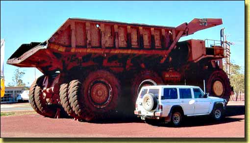
4WD & Dump Truck - Newman
This truck is outside the Visitors Centre, and it has been there at least 13 years that we know of,
and is only a baby compared to what we saw on the Newman Mine tour
Newman is part of the East Pilbara Shire, known for being the largest shire in the world. The main employer is BHP Billiton Iron Ore which is the world's largest open cut iron ore mine. Around Newman are many beautiful gorges ideal for exploring. On a 4WD track to Mt Newman we came across a very steep gravel section. I locked the hubs and engaged 4WD, and with Joan saying repeatedly 'let me out' we climbed over the crest before finally stopping about 1.4kms from the summit.
Like most mining tours we did in the Pilbara, public liability spoils the tour either by ensuring that you don't get off the bus and/or only then at lookouts. Everything is a dirty brown with dust blowing everywhere.
Travelling west the scenery out of Newman soon changed from brown ore graded hills to open areas with gum trees interspersed as part of the Ophthalmia Ranges. We used the Auski Roadhouse as our base and first travelled to Wittenoom. The gorges were absolutely beautiful, totally different to those we later saw in the Karijini NP. Over the next couple of days we trekked, walked, climbed, clamboured, amongst the Karijini NP's recreational areas of Weano & Dales Gorges. It was hot, the flies were bad and the legs were aching - but it was great fun and we slept soundly at night. At Port Hedland we did a tour explaining the processing of iron ore transported by train from the mines around Newman. This included the dumping, crushing, stockpiling and loading of iron ore. Like Newman, everything is on a granitic scale and it is like a Meccano set gone wild.
The caravan park at Marble Bar was most impressive with tree shaded grass sites, no dust, quiet and good facilities. The attractions were many - gorges, jasper, goldmines and even a WWII 'secret' airfield. The Comet Goldmine is the home of Pilbara Jade & Joan purchased some beautiful pieces.
Corunna Downs, the wartime airfield was finally located after 35 Km of unmade and corrugated roads. Other than finding several earthen bunkers (that protected the bombers), old concrete building slabs and the two intersecting runways, nothing is left. Most of the area is covered with spinifex and this makes great camouflage in this type of environment. It is also very prickly on the legs. In 1942 the base comprised two sealed runways, one 2,300 metres, the other 1,650 metres. Both were 50 metres wide and linked by taxiways to bunkers capable of housing 20 aircraft. With the main runway in very good condition I thought I would have a bit of fun, speeding along the runway up to 60 Kmph videoing out of the right hand window, steering with the left hand. We then drove the full length of both runways which were in remarkable condition considering they were last used 60 years ago.
The coolest place was at the bar!
Returning to town we called into the famous Ironclad Hotel. It was 36 degrees. Joan ordered a lemon, lime & bitter, delivered in a massive schooner, and I settled for a beer. We also met some funny characters in this pub. Driving towards Roebourne we briefly called into Whim Creek pub for a beer. It is no longer a pretty oasis as the CP has been closed and the area turned into a mining camp for the nearby copper mine.
Using Roebourne as a base we travelled to the Millstream Chichester NP which included 132 Km of unmade road & corrugations stopping at Python Pool, a permanent freshwater pool on the way. The lagoon at Millstream continues to be a unique oasis in a sunburnt environment, totally out of character to the surrounding area. The underground aquifer fed by the Fortescue River catchment provides a continuos supply of fresh running water giving nourishment to the lilies, palms, reeds, bird-life & native animals.
Weather forecaster advises of unusual high temperatures for the next few days with main intensity in the Roebourne/Karratha area. We later toured the massive Cape Lambert loading facility at Wickham which boasts one of the longest and tallest jetties in Australia, at 2.7 kilometres long and built to a minimum clearance of 17.8 metres above high tide.
Karratha is the commercial centre for the mining town of Dampier which is primarily a 'company orientated town'. Driving along the beautiful seashore near East Intercourse Island a number of local children were playing in the water, and just around the corner was the Hamersley Iron Parker Point loading facility, quite a contrast. We also visited Deep Gorge (4WD only) to view one of the largest collections of aboriginal rock art.
After we left Karratha for Exmouth, and about 100 Km down the track, Joan in her wisdom decided she wanted to go to Onslow. Onslow is primarily a fishing town, but an attraction is Old Onslow. It's an 80kms round trip including 50kms of dirt road. The only substantial building still remaining is the old police station and cells which are built of stone. We had been warned by the Tourist Bureau to stay away from the waters edge as there had been a sighting of a crocodile at the entrance to the estuary of the nearby Ashburton River. We fossicked amongst the ruins of the old town and came across numerous wooden cartwheel rims.
At Exmouth we stayed at the Vlaming Lighthouse CP 17 Km north adjacent to the Harold Holt Communications Base and their huge towers.
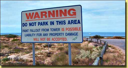
Falling Paint! Sign adjacent to another sign explaining the VLF antennae & towers
Harold Holt North West Cape Defence installation at Exmouth
The area was good for fishing, shell collecting, beautiful scenery, wind surfing and just plain relaxing. The wreck of the ship S.S.MILDURA which was dashed onto the rocks in 1943 is still visible. Nearby is the Cape Range National Park which borders the Ningaloo Marine Park. When we arrived at Coral Bay we got a great camp site overlooking the beach. Joan loves the place and she can understand why so many people rave about it.
With our original tour cancelled we opted for a 2hr snorkelling & coral reef tour. The tour allowed greater travel out along the Ningaloo Reef and most of the teenagers and backpackers on board either went snorkelling, diving or kayaking whilst Joan and I took photos from the top wheel deck of the boat.
Leaving Coral Bay we thundered into this massive head wind which we encountered for the next 130 Km all the way to Carnarvon. We went into town only to find that the Tourist Bureau is closed - in fact, nearly everything is closed - it's the AFL Grand Final between Sydney & West Coast and everyone is watching or listening to the game.
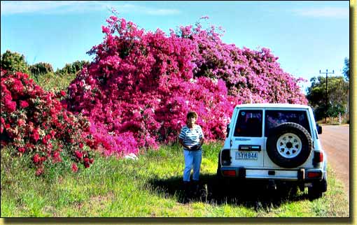
Joan & bougainvilleas at Carnarvon
We were astounded by the height of the bouganvilleas
The famous wooden One Mile Jetty is rough underfoot and you need to watch your step when you are walking as there are a lot of nails protruding through the timbers. The end of the jetty is still fenced off, (a fire at least 15 years ago) but there was evidence that it is finally under repair. We took photos of the 'Coffee Pot' a locomotive which runs the length of the jetty, primarily for tourists but is also used by the local fisherman. Many of the jetties around Carnarvon are off limits for public fishing. If you are not into fishing there are still a number of museums and walking trials showing the historical significance of events around the turn of the century.
Arriving at The Blowholes we found the sea relatively calm and only mild blowhole activity, but enough to give an indication of the power of wind and sea surge. We drove south along the coast and found the fishing hamlet of Point Quobba, a jungle of rundown shacks and old cars interspersed with modern caravans and 4WD's.
On our way to Denham we called into the Hamelin Pool Telegraph Station for a look at the Shell Block quarry & the Stromatolites. Previously you could walk in the water and actually touch the Stromatolites but tourists are now encouraged to use the boardwalk which has illustrative notices detailing the history of the area.
The CP at Denham is right at the end of town and is split on 3 levels; the top having great views but totally open to the elements. The whole park has a solidified shell base which can be very abrasive on the feet. Denham is primarily a small fishing town with the main attraction for tourists being the dolphins at Monkey Mia, a further 23 Km. There are three jetties in Denham and all are open to recreational anglers. The following day we drove to Monkey Mia for the first of the regular dolphin feeding due at 8 am. It was very congested along the waters edge with many school children, but everyone appeared to enjoy the experience. Fortunately the feeding is under the strict control of the Western Australian Conservation & Land Management (CALM) officers who regulate the feeding.
As we progressed along the highway towards Kalbarri we noticed the profusion of wildflowers in pinks, red, blues, yellow, white, mauve & orange. With the recent completion of the coast road between Kalbarri & Northampton there are massive holiday and residential developments all along the coast near Kalbarri.
For our Murchison River Cruise we were the last to arrive with two remaining seats in the bow of the boat which suited us just fine. Whilst cruising the river we had morning tea/coffee & fruitcake and later pumpkin soup. Lunch included beef, kangaroo or crocodile snags washed down with champagne. We then called into an area called Castle Rock and most of us climbed to the top for scenic views of the area. I was a bit queasy going up - unsure if it was the kangaroo or the champagne (I had also drunk Joan's quota). Upon returning to the boat we were greeted with blackberry or lemon meringue pie washed down with white wine.
We also visited the Wildflower Centre which showed native plants in informative surroundings. We walked the 1.8 Km trail which showed the names of some plants that we had already photographed in nature parks and alongside the roads and tracks. In the afternoon we put on our hiking boots and went out to see 'Natures Window' at the Kalbarri NP. Walking along the ledge to the window we then descended the gorge cliff and finally walked across a shallow part of the Murchison River.
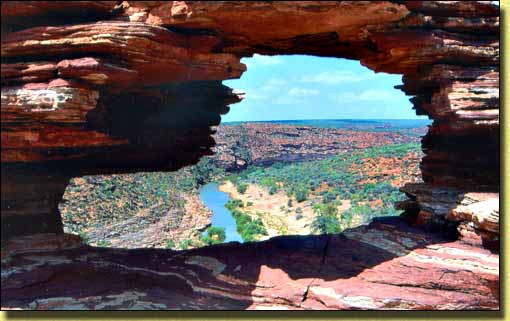
Nature's Window at Kalbarri
Easy to get to, except if you want to climb down to the Murchison River - we did
Driving along the new coast road to Northampton we came across the old convict ruins at Lynton. These buildings were used to allocate convicts to farms for manual labour back in the 1850's. However its isolated location meant supplies were difficult to get and it closed within 5 years. At Geraldton we spent over 3 hours at the new WA Museum and Interpretive Centre which is on the boardwalk at the new Batavia Coast Marina. This museum has numerous displays of the famous Dutch shipwrecks of the 1600 & 1700's, with particular emphasis on the Abrolhos Islands maritime history. Later we stopped at Mount Scott to see the new HMAS Sydney II War Memorial and tribute to the 645 men who lost their lives in November 1941. Although the wreck has never been found the assumption is that its somewhere off the Geraldton coast. Other areas we visited included the Greenough Historical Village and the Chapman Regional Wildlife corridor.
Still waiting - HMAS Sydney II Memorial at Geraldton
Arriving in Perth we caught the bus to visit the Mint & after spending up big we checked out the shops, arcades and London Mall. The new city Busport is central and quite modern and it only cost us $1.20 each for a return ticket. Our trip to Fremantle started at 8 am and 10 hours later we returned to the CP totally worn out & exhausted. During those 10 hours we spent at least 4 hours at the Fremantle & 'E Shed' Markets. We also walked the streets, visited art galleries, the Motor Museum and the Fremantle Maritime Museum. On the horizon we could see the US aircraft carrier Nimitz.
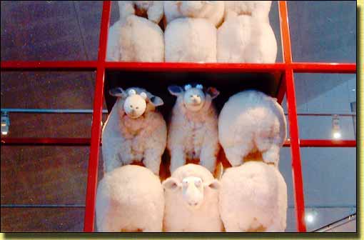
Sheep stacking for transport overseas - Fremantle Museum
With the end of the school holidays considerable additional traffic was on the roads and most buses were running behind time. At the Barrack St Jetty we booked a tour to Rottnest Island for the following day. We then walked along St Georges Terrace to Kings Park which has been extensively updated since our last visit. Primarily funded by WA Lotteries it now includes more walk tracks, lookout towers, garden beds and elevated walkways. A very beautiful area with great views across the city of Perth. More obvious is the very large structure of the stark concrete Busport built along the Swan River.
The Old & the New - Cnr. Barracks St. & The Esplanade, Perth
Driving around Perth in the Rottnest Isle Courtesy Bus, and with so many one way streets and skinny lanes we are really glad we decided to use public transport for all our travel in Perth. With a seat under cover we travelled downstream at 8 Kmph amongst the luxury yachts & millionaire mansions before arriving at Fremantle Pier. The water crossing was relatively smooth and by 11 am we had arrived at Rottnest Island.
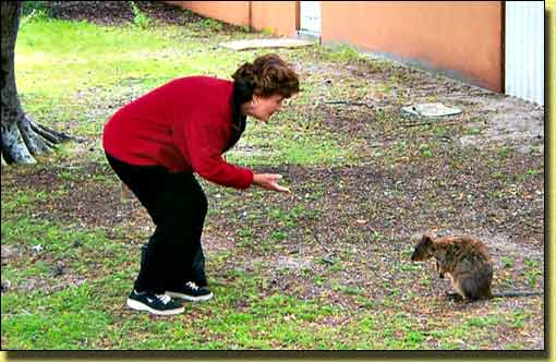
Joan & 'quokka' friend at Rottnest Island
The bus tour was very informative with spectacular coastal scenery, wildflowers, and of course the famed quokkas. The tour circumnavigated the island with an inland trip to the operating lighthouse. It was while we were visiting the 'Mall' & island museum that we located more quokkas moving around the settlement. Returning we were first on board so grabbed an outside deck seat at the rear giving us uninterrupted views of the scenery. Arriving back at 7 pm it had been a long day and we are totally exhausted.
Taking the bypass out of Perth we were soon climbing the ranges towards Northam before stopping at the Kellerberrin Caravan Park. At the Merredin Railway Museum I was disappointed to find very limited rolling stock and only one locomotive. We arrived at Kalgoorlie again late in the afternoon.
With roads now dried out our first trip was to see the ghost towns of Broad Arrow, a former gold mine town of 2,100 people, and Ora Banda. All that remains at Broad Arrow is the original train water tank, a tavern & a couple of houses. There are large operating open cut gold mines in the area. We next travelled inland a further 28 Km to the former 1850's gold town of Ora Banda. The town has a tavern, about 6 houses & a nearby open cut gold mine. Returning along the road towards the highway we drove into the scrub to use our metal detector. We found metal, but no gold.
After lunch we travelled out to the Kanowna Gold Mine to view their open cut gold operations and then found the nearby old ghost town of the same name. Nothing is left of the 16 hotels and 2 breweries. Walking amongst the old dumps we found bottles, horse shoe, tins and other metal objects.
Left Kalgoorlie early finally stopping at Madura (718 Km for day 1), and then Poochera, (812 Km for day 2).
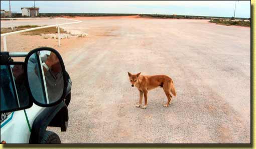
Dingo at Nullarbor Roadhouse
We know otherwise, but as it was the only wildlife in the area, Joan gave it a biscuit
On the road to Kimba we were following a wide load (John Deere harvester) going to Moree, a B Double and in the rear, our rig. With winding roads and few straight stretches it was hard to pass. With constant UHF scanning we heard the first truck give the B Double the OK to pass, and then later we got the OK to pass. The truckies comments were along the lines 'pity all caravanner's don't use UHF'. They then started to discuss an upturned camper-trailer along the road near Nundroo, we had also seen it. Apparently the car driver lost control when trying to pass a road train. The last trailer 'wagged', and the road train driver didn't realise they were trying to pass. On this trip, as far as I am concerned, our UHF CB has paid for itself. We finally stopped at Waikerie a total of 679 Km for the day.
Departed Waikerie early calling briefly into the old historic town of Terowie where we drove up the car-less main street and looked at old buildings.
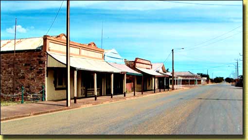
Main Street Terowie. 2 pm and not a person or vehicle in sight - weird!
Just outside Mildura we booked into the Big 4 Crossroads CP. Ken & Lyn Greenwood rang reminding us to visit Woodsie's Gem Shop. We called into Woodsie's Gem Shop at Nichols Point, about 7 Km from Mildura. It was well worth the delayed departure and as well as buying opal we also toured Aladdin's Cave. We are now travelling with a very heavy rain front. We made brief stops at Balranald and Hay where there was localised flooding.
Rain, rain & more rain. Stopped for morning tea at Coolamon and by chance met June & Bruce McKinnon at the bakery coffee shop. At Junee we were very concerned to find out that for some unknown reason our dear friend Ken Greenwood had been confined to bed with severe dizziness. He was so bad that he was not accepting visitors.
It had rained overnight but the morning was fine. Ken was still bed ridden but accepting visitors. Whilst in the town coolant leaked under the 4WD and we had to see about repairs at the NRMA. In the afternoon Ken allowed us to drive his car, so we took Lyn, who had become A'van bound up to Monte Cristo, an old historic homestead built in 1888 and since restored in High Victorian style.
Further heavy rain. Ken is sitting up but needs further rest. In the morning, together with Lyn we visited the Organic Liquorice Factory & in the afternoon the Junee Agricultural Show. At the show Joan swallowed a fly and after a coughing fit she went looking for a cup of tea. Half way through drinking it she noticed a fly doing breaststroke in her tea. Thankfully Ken is now a bit more mobile. The morning started with the customary pancakes and the meeting concluded with an impromptu skit which was agreed to be used at the next AGM at Nuriootpa in 2006.
With the 4WD now supposedly fixed we were the second A'van to depart leaving Ken & Lyn to be safely guided home by Jan & Max Ezzy. The 4WD stalled again in the driveway whilst reversing the A'van and could not be restarted. Only solution was to unhitch the A'van and by using a combination of handbrake and pushing finally got it under the carport in the backyard.
Statistics
Dennis and Joan Thornton
(December 2005)
E-mail: thornies1@optusnet.com.au
Website URL "actavanning.org/index.html"