
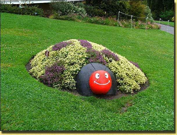
Avanning in Tasmania, 2009
By: Keith Thomas
Preamble:
We have toured Tasmania three times
before, the first time in 1994 with our car and staying at guest
houses, the second in 2002 with our A'van
Sportliner ,and again with our Sportliner in 2006. On each
occasion we think that will be the last, but somehow seem to be drawn back after
a year or two. Given reasonable weather, it certainly is a lovely place
to tour, cycle and hike.
And so it was in 2008, in the middle of a Canberra winter... "Lets go to Tassie again!" "Taswegian Natives" had previously told us that February - March (after the school holidays are over) is the one time of the year when the weather is most likely to be stable i.e. not too wet and not too cold... ideal hiking weather. Incidently, if planning a trip at that time of year, note that Tasmanian school holidays finish later than those on the mainland (or the "other island" as Taswegians refer to it!). Apparently this is on account of there being a lessor number of school terms in Tasmania than on the mainland.
Initial planning at that time (August 2008) just involved deciding when to go, for how long, and booking our return passages on the overnight drive-on drive off ferry "Spirit of Tasmania". The first part was easy... school holidays finished 10th February 2009, so "anytime after that". We chose to take the following Sunday (15th February) sailing, reasoning that the traffic around Melbourne's Station Pier (from where the ferry sails) and on the approach Westgate Bridge Freeway would be less congested than during the working week. Similarly, for the return trip, if we took the Saturday night sailing from Devonport (the Tasmanian port used by the "Spirit"), we would arrive in Melbourne early Sunday morning when traffic on the freeway should also be light. We later found there to be some disadvantages in this strategy... see summary below!
"I cannot leave my garden for more than three weeks at that time of the year" came the familiar lament from my travelling companion! So, that was it... Leg 01 depart Melbourne 15th February and Leg 02 depart Devonport 7th March. Bookings were made via the ever useful Internet. The on-line return cost at that time of the year for two passengers (both qualifying for the senior's discount), a twin bed porthole cabin, and Subaru Forester/A'van camper trailer came to $1,358. There was instant confirmation of booking, and E-Ticket downloaded on the spot. In just a few minutes our booking was accepted, confirmed, paid for via a credit card and we had our tickets. From then until about a week before leaving we could put the trip out of mind, as nothing further needed organising... such is the freedom offered by holidaying in an A'van!
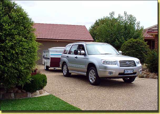
From where we live in the southern suburbs of Canberra ACT to Station Pier in Melbourne is around 730 Km, which we thought too far for one day. There is a nice Top-Tourist caravan park in Holbrook, NSW (Holbrook Motor Village) which is just under half way, so before leaving home we made a phone booking for an overnight stay on a powered site at that park. A couple of days before leaving, out came the "checklist" which has evolved over our 10 years of A'vanning. If everything on the checklist is in place, then no further worries like "Did you remember to pack the electric frypan?" when we are 300 Km from home! The front wheels were dropped off our bikes which were then locked onto the special jigs we have fitted in the Forester. Having the bikes safely locked up in the car and not being exposed to the weather and road filth seemed like a good idea to us. The disadvantage is that the backs of the rear seats have to be folded forward, so there is no room for any further passengers. From outside the car, with the front wheels removed, to a casual observer the bikes look like wheelchairs for the disabled... for which there does not appear to be a great demand as no one has broken into the car to steal them... yet!
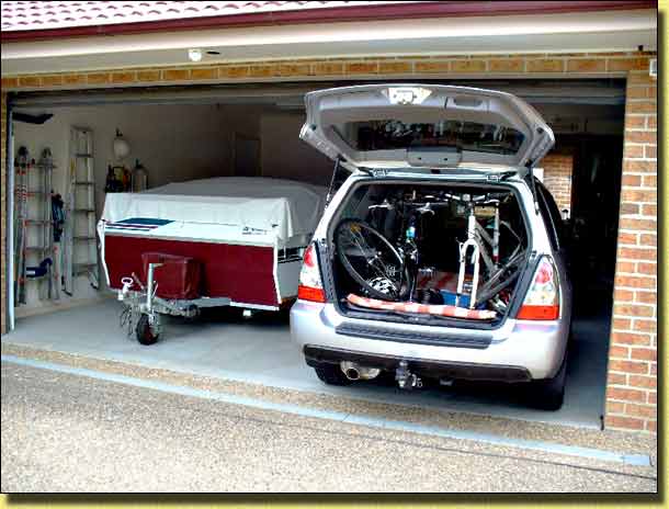
Bikes loaded in Forester
Day 1:
Holbrook being just 320 Km from home meant we could have a leisurely early lunch before setting off. Unlike
when leaving a caravan park, there always seems to be one last thing to do when
trying to leave home. Experience has taught us that we are not really
away until we are finally on the road. Under an overcast sky and a
temperature of 20 C we were off!
Ready for the off!
The journey to Holbrook via the Barton and Hume Highways was uneventful, the scenery confirming that part of the state (approximately below a line south of Sydney) had been in a virtual drought for over five years. The lush green fields of Tasmania (or so we thought) would provide a welcome relief. Those parts of the Hume Highway between Sydney and Melbourne which have not yet been duplicated start just before Holbrook and continue intermittently until you reach the newly constructed Albury bypass. A mammoth effort is now being put into completing that work. According to the roadside signage, the duplication (other than the town bypasses) will be completed by December 2009. The bypasses are scheduled to be completed by December 2011.
Holbrook Motor Village is a well maintained park with first class facilities. The amenities block was scrupulously clean, liquid soap and paper towels were provided, and as the shower cubicles all had sliding screen doors between the shower and drying area there were no wet clinging curtains to have to contend with. There is a large, well equipped camp kitchen, the area having Wi-Fi coverage should you wish to connect your laptop computer or mobile phone to the Internet. The park roadways were sealed and there were loads of wheelie bins throughout. Despite the drought, most of the sites were reasonably grassed, thanks no doubt to the labourious sprinkling undertaken with bore water. This park is currently managed by resident owners, and from our observations, whether a park is owned or just managed is a far better indication as to the cleanliness and condition of the facilities provided, than the number of "stars" in some directory. We found Holbrook Motor Village to be one such park and a credit to its owner/managers.
Happy Hour at Holbrook
Day 2:
Scheduled departure time from Station Pier in
Melbourne for the ferry is 9:00 pm, and you cannot get onto the pier
for loading until 6:00 pm. With just 410 Km to travel from Holbrook, we
had a leisurely breakfast and pull down, and were on the road just after
11:00 am. Once past the roadworks and onto the Albury bypass it was dual
carriageway for the rest of the journey.
Victoria seemed to be suffering from the drought even more so than southern NSW, the only bit of greenery to be seen was where they had been irrigating. There was a stretch of around 25 Km where a fire had burned through on both sides of the highway a few weeks earlier, and we remembered reports of the highway being closed in both directions at that time. Bush fire smoke could be seen over the hills east of the highway in the vicinity of Eildon and Yarra Valley, a reminder of the terrible fires which had raged through that region with such devastating consequences for life and property.
Approaching Melbourne from the north we took the Western Ring Road (M80) which brought us onto the Westgate Freeway (M1), over the Westgate Bridge then filtered off into Port Melbourne. This way is longer than going through the CBD, but is more straightforward and there are no toll roads to negotiate or try to avoid. From the top of the Westgate Bridge you can see over all the port area. Fully expecting to see the red "Spirit" waiting patiently for us, it came as a surprise to find that it was no where in sight. Surely it should be there by now... it was scheduled to arrive at 6:00 am that morning!
As it was only 5:00 pm, we parked as close as we could to Station Pier, found a coffee shop near the entrance, and kept a watch on proceedings. Still no Spirit of Tasmania! Just before 6:00 pm we could see they had started allowing vehicles with caravans onto the pier, so we walked back to the car and joined them. Then to our great relief there she was, "Spirit of Tasmania 1", as large and as proud as ever! Apparently, being a weekend, and it still being considered peak period, both ferries did an overnight and a daytime crossing on the Saturday and Sunday.
Loading with a vehicle involves a security check... a look under the bonnet, open up and a quick look inside the A'van, a warning not to take any fruit or vegetables into Tasmania and any loose gas bottles, jerry cans or firearms have to be surrendered for carriage separately in a special container. The LPG gas bottles fixed to the A'van are acceptable provided the gas is turned off at the bottle. Having survived that, and particularly if you arrive early, there is then a long wait, occasionally inching forward, to the point where you present your ticket and get your boarding pass and cabin "credit card style keys". From there it is just a short drive to the open "sharp end" of the vessel and onto a garage deck.
My only concern when travelling on these ships is that we will not be able to find the car/A'van when we arrive at the other end and the "everybody off" call goes out! If you are not there to shift your vehicle when need be, all those behind you cannot get out. There are five "garage" levels, each having a port and starboard section and all looking identical. The length of each garage deck is almost that of a football field. Access to the garage decks is via a number of circular stairways doted throughout the ship, also all looking identical and after a few circumnavigations of those stairs, any sense of direction is completely lost! As access to the garage levels is locked while at sea, my "system" is to park/lockup the car, walk up the stairs to the cabin levels, find our cabin, dump our overnight bags, then try to find our way back to the car while the garage decks are still open. So far the system has worked, but I still get a great sense of relief when on opening the stair door, I see our car/A'van standing just where we hoped it would be! Not everybody worries about where their vehicle is however until they cannot find it... calls over the PA system for "THE DRIVER OF VEHICLE REGISTRATION NUMBER ***-*** TO PROCEED TO THEIR VEHICLE IMMEDIATELY" are not uncommon!
Following a quick shower in our cabin, it was down to the "Waves Eatery" for a meal. This self service bistro has a wide variety of hot and cold dishes at reasonable prices. On the way back to our cabin we purchased a National Park "Holiday" Pass from the "Tourism On Board" shop. This gave us eight weeks vehicle and passenger access to any of the state National Parks and cost around $60. We were back in our cabin by 9:00 pm just as the "Spirit" pulled away from the pier for yet another crossing of Bass Strait.
Day 3:
The overnight crossing of the Bass Strait was most pleasant... the gentle rock
of the ship being a reminder of my coming to Australia from the UK on the
P & O liner Oriana in 1964.
Crossing the strait can at times be very rough... one of the A'van Club members told us of being on the same
ship which had to turn back when waves smashed windows on the bridge!
Scheduled arrival time was 6:00 am so the alarm was set for 5:30 am, and after
a quick shower we were back in the Waves
Eatery where the previous evening offerings had all been replaced
with breakfast food. Sure enough, right on time, we were into the calm
waters of the Mersey River in
Devonport and were being roped up to the quay.
Once alongside, the call went out for drivers and passengers of vehicles on our garage level to proceed to our vehicles. The "system" worked and we were soon in the Forester, itching for the off. As anticipated, there were many calls over the public address system for missing drivers! Once off and onto the quay, it took nearly an hour to clear "immigration". The bringing in to Tasmania of fruit and/or vegetables is strictly forbidden. "Immigration" involves a further interrogation as to whether or not you have any fruit or vegetables. Any form of trailer you might be towing has to be opened up, and a beagle sniffer dog checks out the interior, particularly the fridge. If he finds anything, he is rewarded with a treat of some kind, which ensures he tries pretty hard! In our case, opening up the A'van seemed like too much trouble, so we were waved through... must have honest faces.
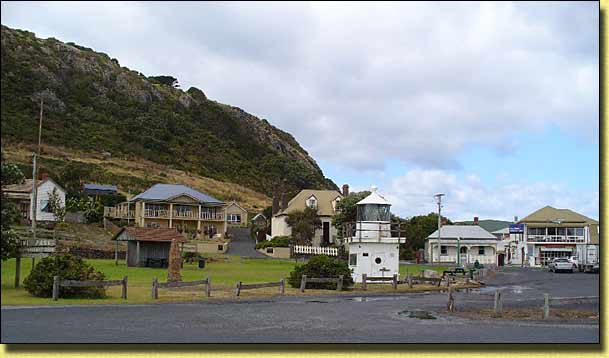
Firstly, we had to find a fruit shop to replenish the fridge and store cupboard and found one in Devonport near the Coles and Woolies supermarkets on the other side of the river. Having toured Tasmania on three previous occasions, exploring areas where we hadn't been before seemed a sensible idea. The caravan park at Low Head near George Town (Low Head Tourist Park) had been recommended to us as a nice place to stay, so we drove cross country via Exeter and Batman Bridge over the Tamar River to George Town Visitor Centre and picked up information on what to do and see in the district. Low Head was just a further 3 Km on from George Town.
First impressions of the countryside was that other than for the irrigated areas, the landscape was just as brown as it was in the Canberra region. So much for our yearning for lush green pastures!
George Town lays claim to being the oldest town in Australia. Having heard these sorts of claims from so many places all around Australia before, we queried this at the Visitor Centre. Turns out we need to distinguish between towns and cities! In the early days, a settlement was quickly established at George Town as the French were also showing interest in doing something similar.
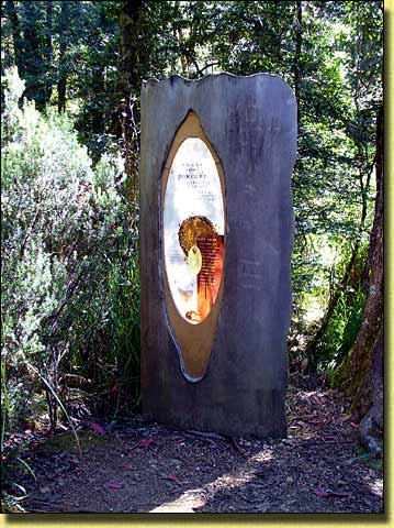
We were not disappointed with the caravan park. Grassy sites, sealed roads and the new amenities block was quite luxurious. The rest of the day was spent on our bicycles exploring the nearby Fairy Penguin Rookery viewing platform, the East Beach location of where the first Bass Strait submarine telegraph cable was brought ashore in 1859, and Low Head Lighthouse Precinct.
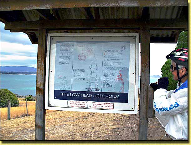
Lighthouse Precinct interpretive sign. Note the green grass!
The current red and white painted stone lighthouse was built in 1888 and is the third navigation beacon built on that site, the first being in 1804. Nearby is the historic fog horn, originally commissioned in 1929 and in continuous use until 1973. Restored to full working order in 2001 by the Progress and Heritage Association, it is one of the few operational systems of that type left in the world and can be heard at 12 noon on most Sundays (hearing protection is recommended!)
We then cycled back to George Town and followed the Self Guided Tour of the historical sites and buildings in the town. Armed with the leaflet from the Visitor Centre, it proved a pleasant and informative way to spend a couple of hours.
Day 4:
During the night we could hear the grazing of
"furry friends" outside the A'van, and on awakening in the morning,
evidence of their being there was all around. The park staff were already
busy with brush and pan clearing up their droppings from the roadways. Any
on our site however was our problem! We carry a grass rake specifically for
this purpose, as Low Head Tourist Park is by no means the only place where this
happens.
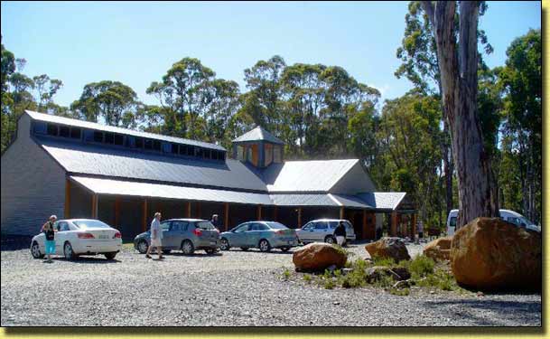
Leaving the A'van at the caravan park, we spent the day in the car exploring further afield. We finished up at the pleasant town of Scottsdale. On the way through, we had a look at the caravan park in Bridport, and decided we had made a good choice in staying at Low Head. One of the primary attractions at Scottsdale is the futuristically designed Forest and Eco-Centre. We stayed for over an hour inspecting the displays and watching videos of the history of the region and details of places of interest worth visiting.
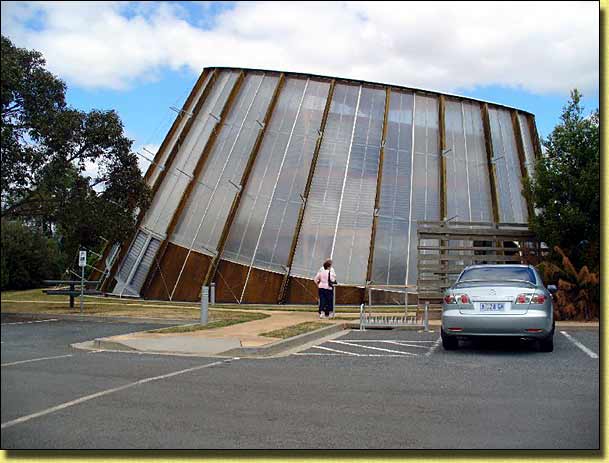
Scottsdale Forest Eco-Centre
Whilst having our lunch at the public North East Park we noticed there appeared to be quite a few caravans and motorhomes set up, and obviously staying a while. It appears that "roadside stays" such as these are fairly common in Tasmania. For this particular park, you can stay for up to 7 days maximum, apparently at no cost. There were toilets, but no other amenities or mains power. Other such "roadside says" we came across allowed a stay of up to 22 hours maximum. We prefer the security, power and hot water showers provided at caravan parks, so decided we would not be joining them! Another thing we came across in Tasmania (but not on the mainland) were council provided maps of where "black water" could be dumped. Obviously, Tasmania goes all out to attract tourists having their own accommodation incorporating showers and toilets.
Driving out of Scottsdale on the Tasman Highway we came across a strange sight, and stopped to investigate:
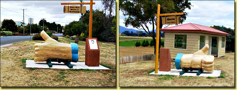
"G'day" welcome and "Hooroo" goodby carving
Created by Joshie Janoschka, it has "G'day Mate, Welcome to Scottsdale" on the town approach side, and "Hooroo, Travel Safely" on the leaving town side. A plaque adjacent to the thumb gives the following explanation:
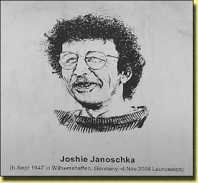 Joshie Janoschka When a tree fell across his gate after a fierce storm, Joschie did not cut it into firewood, he carved a Big Thumb. That was his sense of humour. What amused him more were the number of people who stopped to take a picture of his Big Thumb. Others have the Big Banana, the Big Pineapple or the Big Prawn, but Joshie created the Big Thumb which delighted him. What does it mean? He had a dozen explanations. It really was a tree that fell across his gate. Invent your own explanation - he would heartily approve. |
Note the neat picnic shelter near the thumb. The glazed windows look out over rolling pastures, and it would be a pleasant place to have lunch, whatever the weather.
Day 5:
We chose St Helens on the east coast
for our next stay, a distance of only 220 Km (nowhere is far in Tassie!).
Just past Scottsdale, off on the Ringarooma road is a little village called
Legerwood. Legerwood is
famous for the wood carvings in its Memorial Park.
This notice on one of the trees in the park tells the amazing story of these carvings:
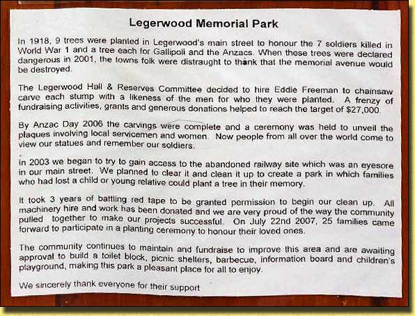
The story of the carvings
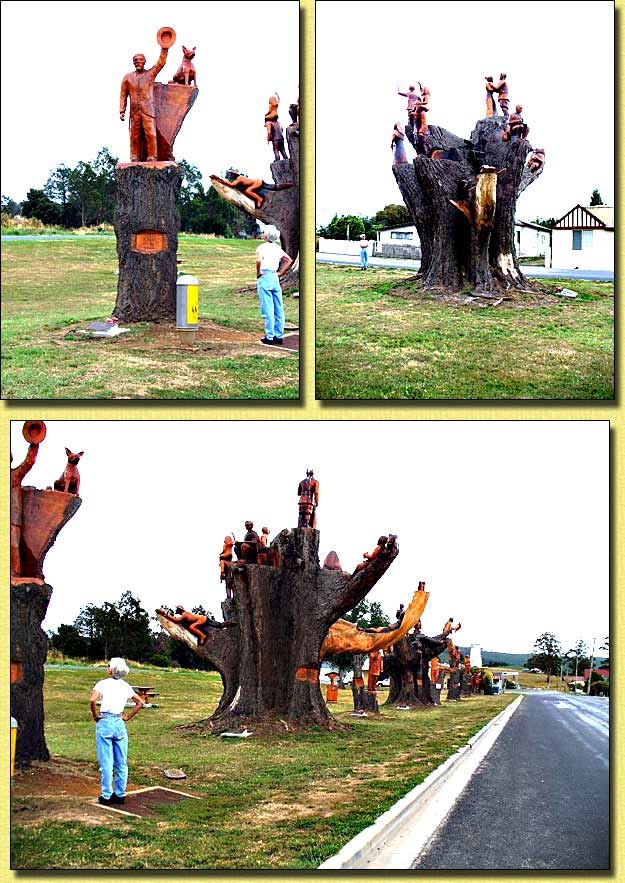
Just some of the carvings in Legerwood Memorial Park
Driving through St Helens, we noticed there was a strong sewerage smell throughout the town, apparently coming from the sewerage farm on the northern outskirts. Fortunately, the Big-4 St Helens Caravan Park where we stayed, is well to the south of the town so was not affected. The caravan park served our purpose... nothing special, but being a Big-4, was by far the most expensive that we stayed at for a powered site, without there being anything special offered to justify it.
The town of has a good selection of shops, so we took the opportunity to restock the A'van, as we intended to go on to Coles Bay after St Helens.
Day 6:
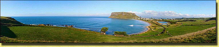
St Helens is a good base for exploring the "Bay of Fires", with the brilliant
orange lichen on the rocks. The front cover on the 2009 ESE-2C (Easy to See) Calendar is of Picnic Rocks at Mt William National Park which had wet our
appetite at home. We were not disappointed when looking at the real thing!
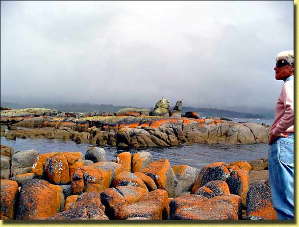
Red Lichen covered rocks in Bay of Fires
We explored the southern section of the "Bay of Fires" conservation area extending from Binalong Bay to The Gardens. Good walking and "rock hopping" area with fine coastal views.
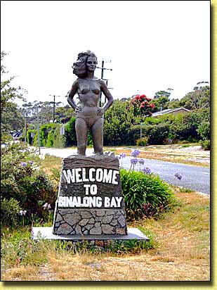
Nice welcome to Binalong Bay!
Back to the A'van for lunch then we drove to St Helens Point and walked to Beerbarrel Beach Lookout from Burns Bay. Again, fine coastal views, with red lichen covered rocks for as far as the eye could see.
Day 7:
Our next caravan park was at Coles Bay,
right in the middle of Freycinet National
Park. From St Helens to Coles Bay is only around 130 Km, so we
were comfortably set up at the
Big-4 Iluka Holiday
Centre in Coles Bay by lunch time. Access to many of the sites
on the side of a hill at this park is awkward, particularly if you have a large
caravan or motorhome. Naturally, an A'van Sportliner towed by a Subaru
Forester could easily be positioned and oriented for the best view on any of the
sites! The amenities block was equipped with the obligatory Big-4 "tatty mop" in a bucket of filthy water!
After lunch, we walked the couple of kilometres up the road to the National Park Visitor Centre to pick up local information, maps and get advice about the walking tracks. On the way up we passed Freycinet Lodge where we stayed during our 1994 trip, before we bought the A'van. It was nice, and provided good accommodation, but we do prefer the freedom of touring in our A'van.
The red granite "Hazards" as seen from the Visitor Centre
All walkers are catered for, from short 10 minutes return walks, through longer day walks (five hour loop), to much longer overnight walks. The choice is yours and obviously depends on your fitness, experience and the time available. We decided to try the Wineglass Bay / Hazards Beach (five hour loop) walk the following day.
Day 8:
The start of the Wineglass Bay Lookout
walk is a further 4 Km on from the Visitor Centre, so we drove to the car park
at the start of the walk. This walk is probably one of the most used in
Tasmania and was relatively busy. The track is well paved and in good
condition, but the pull up to the saddle between Mt Amos and Mt Mayson is fairly strenuous and would be
considered "challenging" for those not accustomed to bushwalking!
For those who think they have gone far enough, this "path side furniture" might be a pleasant place to await the return of the rest of their group! It was designed and constructed by students from the School of Architecture Zammi Rohan and Stephen Geason in 2000 specifically for that purpose!
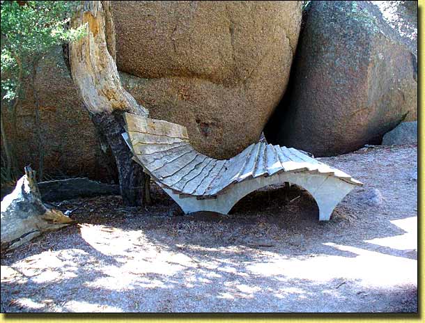
Reclining Chair on track to Wineglass Bay Lookout
From the lookout, we had one of Tasmania's most well known views over Wineglass Bay. We overheard someone say that this was the first time she had seen a view which actually lived up to the postcards in the tourist shops!
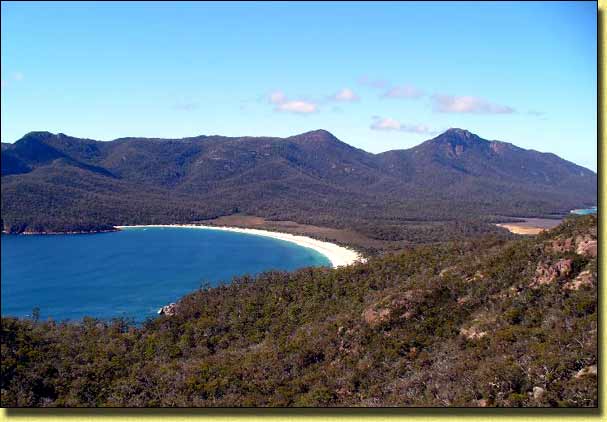
Picture postcard perfect Wineglass Bay
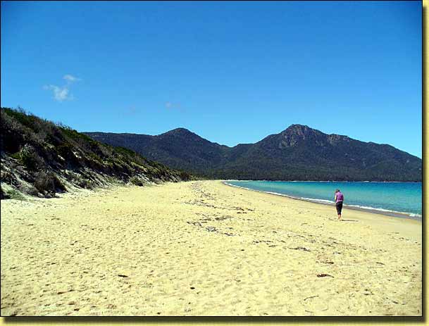
Backtracking the way we had come would have only given us a 1 hour walk and we were ready for quite a bit more, so took the "long way" back. From the lookout, the track plunged quite steeply down to Wineglass Bay Beach. Up close, the sand is not nearly as white as it appears from the lookout. It is a beautiful beach nevertheless. From the beach, a further track crosses the "isthmus" to Hazards Beach, from where there are really good views of the Hazards to the north (Mt Parsons, Mt Amos and Mt Mayson) and Mt Graham and Mt Freycinet to the south.
Mt Graham and Mt Freycinet from Hazards Beach
Lunch was taken on the rocks at the northern end of Hazards beach, then the longish but easy trek on the track that follows the coastline around the base of Mt Mayson back to the carpark. As expected, we slept well that night.
Day 9:
Just north of Coles Bay, the Tasman Highway passes through the pretty town of
Bicheno. As the weather was a
bit dull, we decided to have a look around there in the morning. From
Waubs Bay, the Foreshore Walking Track follows the coastline south and we
were surprised to see a flock of penguins on
Governor Island Marine Reserve which is just a stone throw (over
"The Gulch") from the walking track.
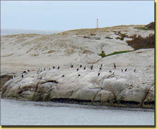
Penguins on Governor Island Marine Reserve at Bicheno
Further on, we came to "The Blow Hole". Like most of these attractions ("you should have been here yesterday"), it was a little temperamental, but did give the occasional good gush. Of course, as soon as you put the camera away there is a monster!
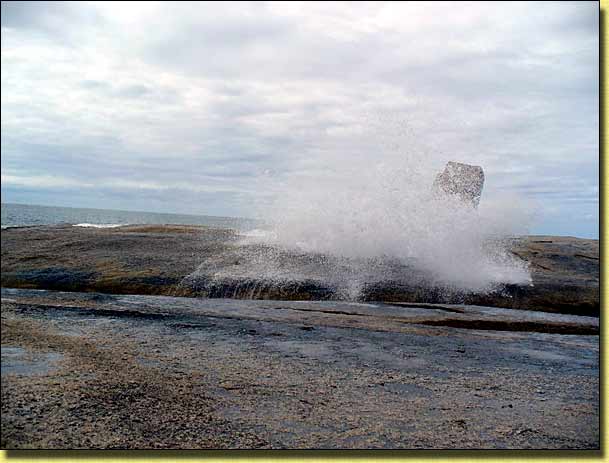
Bicheno Blow Hole
The track ended at Rice Pebble Beach from where we retraced or steps. On the way down we noticed that there were many blackberry bushes near the track. Autumn is when they are ready to eat, and we made the most of the opportunity. One of the joys of coming to Tasmania at this time of the year, is the ready availability of ripe blackberries, just begging to be picked in so many places! Unlike on the mainland, where blackberry bushes are considered a noxious weed, spraying of blackberry bushes does not appear to be undertaken in Tasmania.
On the way into Bicheno, I noticed a nondescript looking building on the side of the road with a "Bicheno Motor Cycle Museum" sign outside. Having an interest in restoring classic period motorcycles, I made a mental note to check it out on the way back. So, on the way back, Pam curled up on the front seat of the car and resigned herself to a long wait! When we were last in Tamworth in NSW, I came across a similar sign and went in, only to discover that while there was a good collection of well-restored motorcycles, they were from the 1970 to 1990 period, which is of less interest to me. "Once bitten twice shy", before parting with my money I told the man at the desk "Before squandering the kid's inheritance, I am primarily interested in British and European motorcycles made between 1940 and 1970". "I don't think you will be disappointed" was his reply. Sure enough, in that building was the finest collection of beautifully restored and presented motorcycles from that period that I have seen anywhere... including the National Motorcycle Museum in Nabiac NSW. There were upwards of 50 machines, all sympathetically restored.. for riding as well as looking at. Some had been restored by the museum owner himself, others by private owners, who when not riding them, garaged them at the museum for the enjoyment of the likes of me!
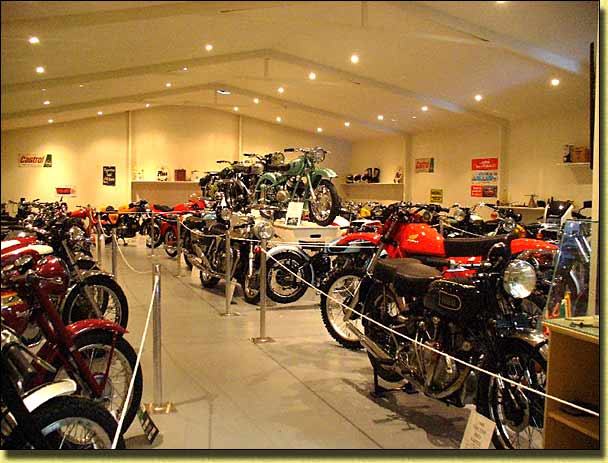
Part of Bicheno Motorcycle Museum
Back to the A'van, then a quick dash back into the National Park, this time to Sleepy Bay and then on to Cape Tourville. Well worth the visit, the extensive board walks making it easy to take in this sort of scenery:
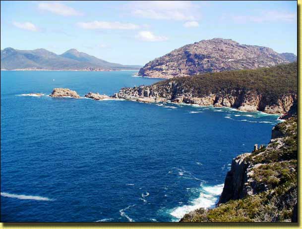
Coastline near Sleepy Bay and Cape Tourville
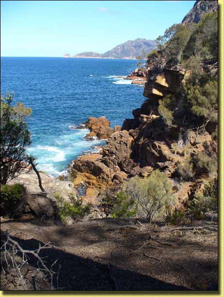
Coastline near Sleepy Bay and Cape Tourville
Day 10:
From Coles Bay to New Norfolk is around
240 Km, so after a leisurely breakfast and pulldown we were on our way, arriving
at New Norfolk just after mid day. We chose to stay for four nights at the
Council owned
New Norfolk
Caravan Park... grassy sites, clean and spacious amenities and at
$22 a night for two people on a powered site was the cheapest we stayed at in
Tasmania.
After lunch we walked up to the shopping centre, did some shopping for provisions, and idly explored the township on foot. With neat colourful parks, stately oaks, poplars and pine trees it is an attractive town, nestling as it does on the banks of the willow-lined Derwent River. There is a wide range of early architecture from grand mansions through humble cottages to oast houses.
The Anglican Church of St Matthew, built in 1825 opposite the delightful Arthur Square, lays claim to being one of the oldest continuously used church on the same site in Australia. A wall plaque inside the church raised interesting questions of a personal connection, which will involve some genealogical searching when we get home!
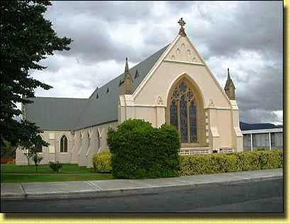
St Matthew Anglican Church, New Norfolk
Day 11:
New Norfolk is a ideal base from which to explore the surrounding areas.
As Mount Field National Park is just
30 mins drive away, we decided to spend the day bush walking in that park.
Mt Field National Park, together with Freycinet National Park are the oldest
national parks in Tasmania. The Visitor
Centre near the western entrance provided us with all we needed for
the day and a second visit in the way of maps advice about the various walking
tracks.
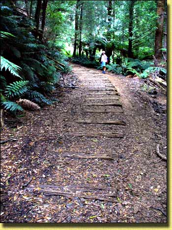
The best known of the short walks is the Russell Falls walk which starts at the Visitor Centre. It is an easy well paved walk and quite suitable for wheelchairs.
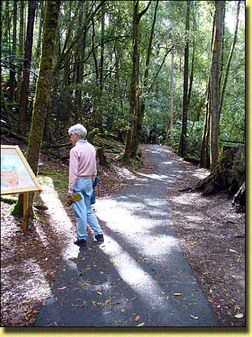
Interpretive sign on track to Russell Falls
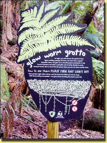
Directions at "Glow Worm Grotto"
The sign reads:
|
how to see them: PLEASE TURN ANY LIGHTS OFF! Once you have night vision and can read the secret text below you are set to go. Walk slowly holding the handrail - the glow worms are along the track to your left. |
The secret text reads:
|
|
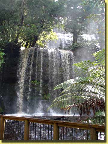
Russell Falls from lower platform
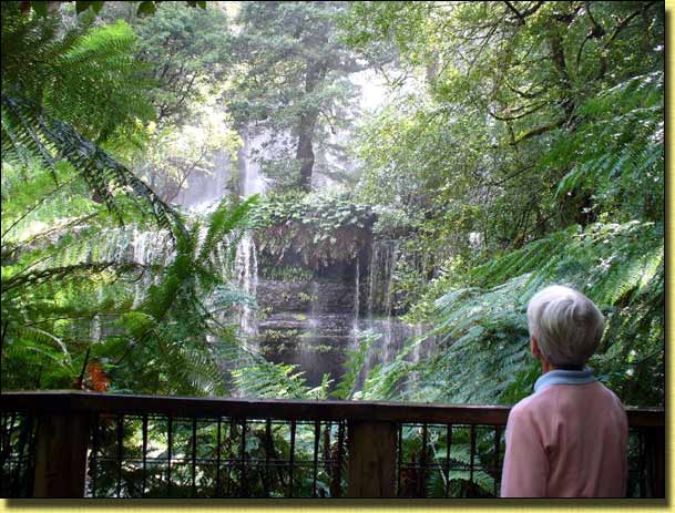
Russell Falls from middle platform
The track continues to Horseshoe Falls, Tall trees Circuit and Lady Barron Falls, the complete circuit taking around 2 hours.
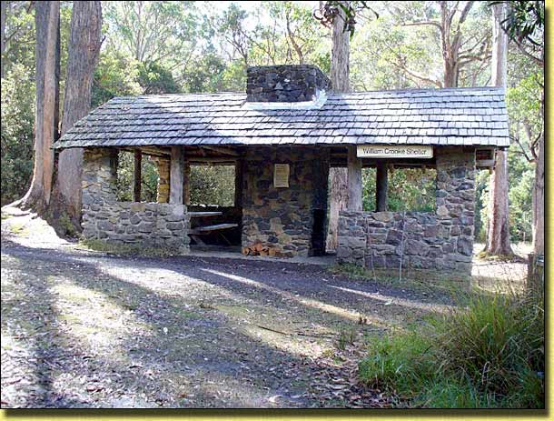
William Crooke Shelter, one of many in Tasmanian national parks
William Crooke is considered by many to be the true father' of Mt Field National Park. In 1912 he was instrumental in the formation of the National Parks Association. Crooke was impressed by the far sighted national park model adopted by the USA, believing that flora, fauna, and scenery preservation was an end in itself, and he was committed to protecting land in a similar manner for future Australians. He successfully lobbied government for extensions to the Russell Falls Reserve, and the efforts of the National Parks Association under his leadership resulted in the Scenery and Preservation Board Act of 1915. The Act covered historic, scenic, and wildlife areas, and it was under this act that the Mt Field National Park was declared and protected in 1916.
Day 12:
It was dull and drizzly, the first wet day of the trip. "Hobart is just a 30 minute drive away, and we didn't
really see the Royal Botanic Garden on our previous trips".
So Hobart it was. Established in 1818, it is Australia's second oldest Botanic Garden - just two years
younger than that in Sydney.
As usual, first port of call is the Visitor Centre where we pick up a brochure with a map of the gardens. The Visitor Centre includes the Garden Shop, a display gallery, a kiosk and a restaurant with a lovely vista over the rolling green lawns. Up to then, all we really knew about the gardens was that somewhere in here was Pete's Vegi Patch, made famous by ABC TV Gardening Australia presenter Peter Cundall . That was all about to change!
The "Friend's Cottage", which originally was the home of the head gardener, is now furnished as it would have been in the early days, and is used by the volunteer "Friend's of the Gardens". At the time of our visit, they were exhibiting an embroidered "hanging", depicting various scenes from the garden. The embroidery was in a microscopically small cross stitch on a very fine weave backing. This is just a portion of the hanging, and depicts Pete's Patch:
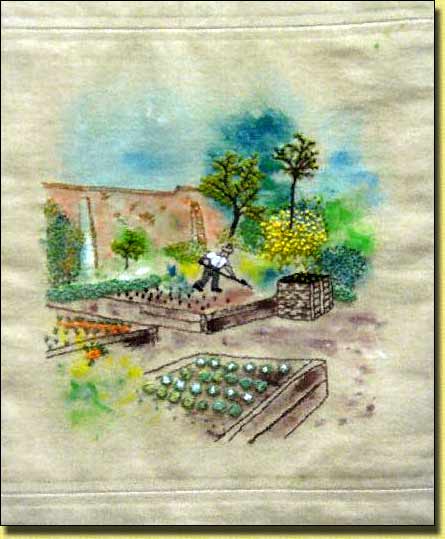
Embroidered Pete's Patch
Outside the cottage, a full size carved wood figure depicted the "Head Gardener" practising his profession:
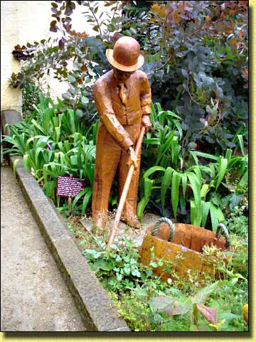
Wood carving of the Head Gardener tilling the soil
Novelty planting in lawn
Display setting in the Conservatory
Pete's Vegi Patch
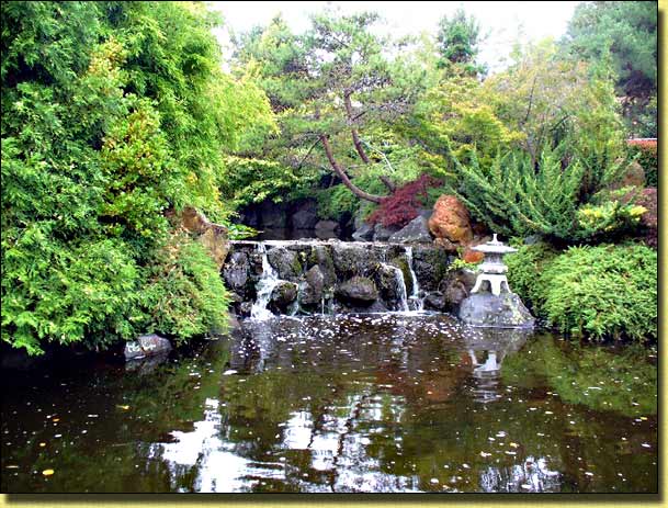
Scene in the Japanese Garden
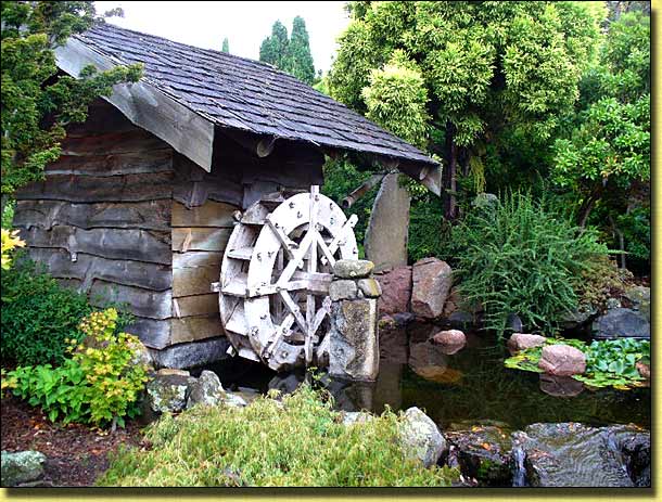
Waterwheel powered "Mill" in Japanese Garden
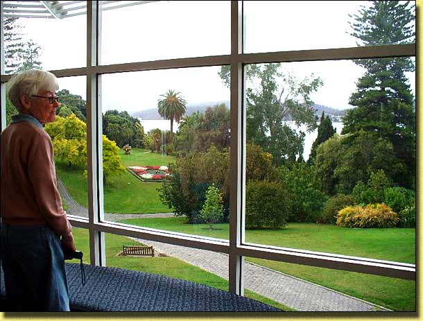
View from Restaurant window
Also, of particular interest as being something to see out of the ordinary, was the "Sub-antarctic Plant House". Set inside a large low temperature and humidity enclosure, with icy winds blowing through, it was filled with the closely related flora of wind blown Macquarie Island. The plants all appeared to be enjoying the climate, which was more than could be said for us. We were not really dressed for sub-antarctic weather, but it was nevertheless, most interesting!
Day 13:
Being a nice day and our last in New Norfolk before moving on, we thought it
time to try something a little more strenuous than what we had been doing over
the last few days. The Mount Field
East circuit is billed in the Mt Field National Park brochure as a
"Longer day walk (five hours return)"
and "Challenging".
The start of the walk (Lake Fenton end) is about 12 Km from the park entrance, along the narrow, winding, uphill climb Lake Dobson gravel road (don't even think of bringing your Winnebago or 5th wheeler on this one!). In most places, if you meet a vehicle going in the opposite direction, one or both of you has to take to the side gutter to pass. The full time all wheel drive of the Subaru gave us a feeling of confidence in being able to get back onto the road, and it didn't let us down.
At the start of the walk, near Lake Fenton (a reservoir supplying 20% of Hobart's drinking water), we were literally in the clouds. Once past Lake Fenton the track involved climbing along a steep, narrow, stony watercourse, which was anything but pleasant. Eventually we reached the top of the ridge, the clouds had cleared somewhat and walking became a little easier. From there up to near the summit the walk passed through light scrubby forest onto open moorland (Windy Moor) which was very boggy... a bit like the walk to Mt Kosciuszko from Thredbo in NSW, but without the benefit of the boardwalk!
Not far from the summit we passed the only other people we saw that day. They were a couple from Wanniassa (a suburb of Canberra adjacent to where we live). They were walking the loop in the opposite direction to us. What is it about Canberra people that cause them to spend their time in these inhospitable places... adventurous, tough or just simply silly?
The final climb to the summit involved following "markers" (small piles of stones on larger rocks) over what is just a great big pile of large stones. Unlike rocks, which seem to be part of the landscape, these stones look as if they have just recently been dropped there from some huge excavator in the sky. That we succeeded in negotiating them without twisting, spraining or breaking an ankle was truly amazing!
The summit is about half way round. Rather than continue the circuit, we returned the way we came. To continue would involve more of the same, followed by a 3 Km walk back up Lake Dobson Road to our car. When we finally got back to the car, the conclusion was that neither of us had particularly enjoyed the walk. On a nicer day, and if the ground had been a little drier we might have thought differently.
Day 14:
From New Norfolk we moved on to
Tarraleah
which is just 85 Km up the Lyell Highway. The village was originally built
to accommodate construction crews and their families when the Hydroelectric Power Schemes were being built
in the region. The 300-acre estate has since been taken over privately and
is set up to provide a wide range of accommodation for the tourist. We of
course were interested in the Highland Caravan
Park which is advertised as having
"outstanding facilities in the heart of the Tasmanian Highlands and on the edge
of a World Heritage wilderness".
At "book in" we were told we could select any site we liked and were given two "keys" for the amenities. Despite the "exotic" key rings, no deposit was required... just throw them in the box by the door when you leave! These no doubt emphasised we were in "fishing territory".

Tarraleah amenities block keyring
The sites were grassy with satisfactory power and water at each site. On checking out the amenities however, it appeared the keys were unnecessary as the doors did not have any locks on them, and the place was filthy... this was early afternoon. The showers were virtually unusable as there was a complete absence of water pressure and the water just dribbled from the shower rose. Mention of the state of the amenities at the office resulted in a call to "housekeeping".
Tarraleah's reason for being
Tarraleah Lodge
During the hydro construction phase, this building was the site hospital. It is now the primary accommodation
centre and called "The Lodge".
In keeping with the "highland image",
these friendly creatures graze contentedly near the camp sites.
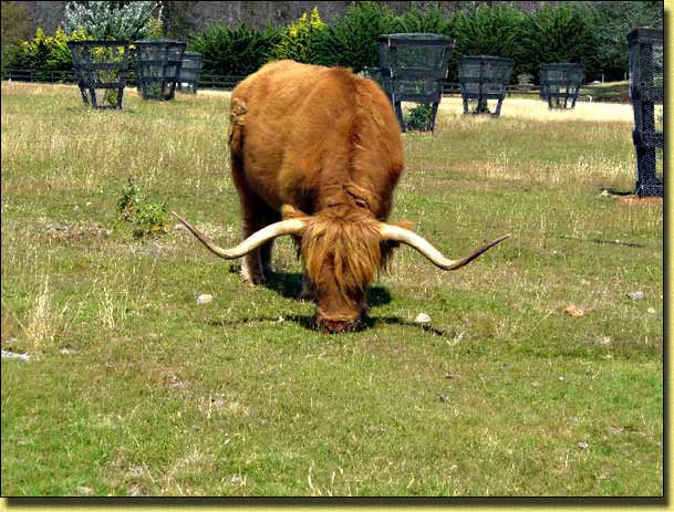
Highland Cattle
In the afternoon we walked the "Eagle Track" which wondered down the hillside to the valley floor, along the valley floor and back up again to the road leading into the village. We saw quite a few more highland cattle and the walk gave us a good appetite for dinner that night. "Housekeeping" had been, and the amenities were a little more presentable. Despite our having good water pressure on our site (which was almost level with the amenities block), the showers were still the same.
Throughout the night, we could hear the continual cutting in and out of the cold room compressors in the nearby pub.
Day 15:
This morning, there was no water whatsoever in the amenities block. The
"office" response was "Oh that sometimes happens,
I'll put a call through to Maintenance. It should be fixed in a couple of
hours." In a couple of hours we were back to the "dribble",
and that is how it was for the remainder of our stay.
We decided to spend the day at nearby Lake St Clair in "Cradle Mountain - Lake St Clair National Park". On the way, near Derwent Bridge, we stopped to see the WALL.
Gallery building, containing Greg Duncan's "the WALL in the wilderness"
The following summary is taken from the WALL brochure:
"The WALL in the Wilderness is artist Greg Duncan's sculpture in "commemoration of those who helped shaped the past and present of the Central Highlands of Tasmania". It is a work in progress. The Wall is carved from three metre high panels of timber, most of which are rare Huon Pine. Together, the carved panels will tell the history of the harsh Central Highlands region - beginning with the indigenous people, to the pioneering timber harvesters, pastoralists, to Hydro workers and miners. Opened in March 2005, Greg has now completed 38 panels. When complete it will measure 100 metres in length and 3 metres high, using 10 different subjects to portray the history of the area. It is expected to take five to seven years to complete." |
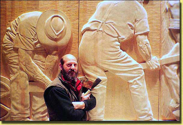
Greg Duncan and a small portion of his "the WALL" sculpture
Photo from "the WALL" brochure, courtesy James Lauritz and Rob Baxter
Definitely, a "do not miss experience"
if you are anywhere near Derwent Bridge.
Turning off the Lyell Highway in Derwent Bridge brought us to the Lake St Clair Park Entrance. The "Visitor Centre" supplied our usual requirements, namely maps of walking tracks and local advice. We took the Watersmeet and Platypus Bay circuit and followed the "Overland Track" for a little way. Continuing to Cradle Mountain would have to wait for another day! We then checked out the Larmairremener tabelti Aboriginal cultural walk which proved quite illuminating.
Interpretive sign along the "Aboriginal Cultural" walk
Whilst there, we checked out the National Park Caravan Park at Derwent Bridge. The sites were under heavy eucalypt tree cover, amenities were very dirty and showers were $1.00 for six minutes max. Add that to the National Park fee and the site fee (unknown), it could be an expensive overnight stay. Power cables to the few powered sites were just strung overhead between trees. An eye sore, and a likely source of danger in high winds. There did not appear to be any water taps on the powered sites.
Any sleep that night was difficult, not only on account of the cold room compressors, but being a Saturday night, the alcohol fuelled "patrons" made sure that we would all be well aware of their presence until well past 3:00 am.
Source of all the noise until well past 3:00 am
Day 16:
Rosebery, our next stopover, is
around 200 Km from Tarraleah so we had travelled to there and were all set up
at the Rosebery Cabin & Tourist Park
by lunchtime. Rosebery is a mining town (gold, silver and zinc), deep in
the heart of Tasmania's West Coast Wilderness
. It is conveniently located for a day visit to the Cradle Mountain National Park and for checking
out Tasmania's tallest waterfall - Montezuma
Falls. The park provides basic but perfectly adequate
facilities for all we needed and we were able to restock the fridge at the small
town.
In the afternoon we drove to Stitt Park and took the walking track to Rosebery Park and on to Stitt River Falls which were worth the walk. Not having any map of the area, we just followed the track, and had no sense of direction or where we were. On looking up from the falls however, we were surprised to see our A'van, less than 100 metres away... we had virtually walked back to where we had started. Unfortunately, the car was still at Stitt Park, over an hour away on foot!
We had dinner in the A'van, and after a game of Scrabble (I lost to Pam as usual) were getting ready for bed when there was a distant rumble which built up to a deafening roar, giving the impression that the whole hillside was exploding! The noise then gradually subsided until the previous silence was restored. As it was dark, we had no idea what caused all the noise.
Day 17:
As the weather was fine, we decided we would drive the 75 Km to the Cradle Mountain National Park and to spend the
day exploring the region. Just as we were about to leave, there was that
distant rumble again. This time it was light, so we were able to check out
where the noise was coming from. Just around the corner, in what is a deep
narrow valley surrounded by high hills, was a high iron railway bridge spanning
the Stitt River. The noise was caused by a locomotive hauling a large
number of waggons over the bridge, presumably from some mine or other.
Source of the thunderous noise
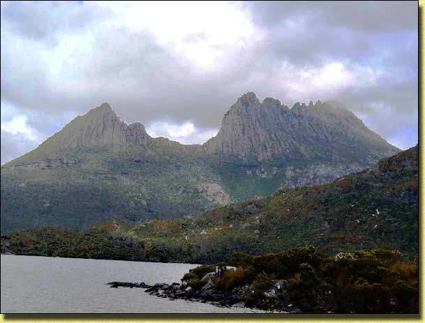
Since our last visit to the region, there have been a number of changes around the entrance to Cradle Mountain. Previously, we were able to drive to Dove Lake, but following a number of accidents on the road between the Visitor Centre and Dove Lake, we understood we would no longer be unable to do the same. Instead, there is a shuttle bus system which runs between a new "Transit Terminal" to Dove Lake via the Visitor Centre. The cost for using the shuttle bus was included in our National Parks Holiday Pass (In fact, it appears you can still drive right down to Dove Lake, but the road is narrow, car parking is limited and it is not known for how long this will continue to be permitted)
We parked in the Transit Terminal and took the shuttle bus to the Visitor Centre. The Shuttle busses seem to run every few minutes so there was very little waiting. Armed with the "walks" brochure, we picked up the next shuttle bus going to Dove Lake.
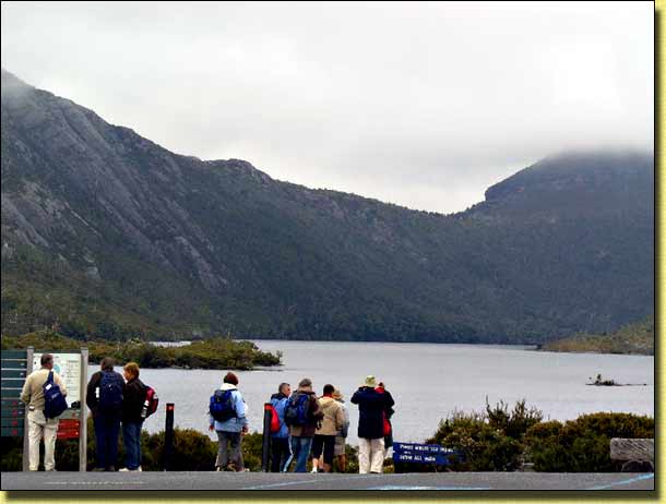
Start of Dove Lake Walk
The Dove Lake Circuit is around 6 Km and typically takes 2 - 3 hours ( depending on your energy level!). The track goes right around Dove Lake and beneath the towering spires of Cradle Mountain... probably the most recognised mountain in Tasmania. The walk is pleasurable and easy, and very popular. Significantly, it is the first walk in the "Tasmania's 60 Great Short Walks" booklet.
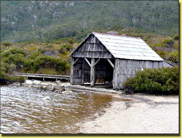
Boatshed on the shores of Dove Lake
Seeing we had plenty of time, instead of taking the shuttle bus back, we decided to walk from the Dove Lake Circuit back to the Visitor Centre on the new Cradle Valley Boardwalk. This runs for 5 Km from Ronny Creek to the Visitor Centre. To get to Ronny Creek however, we first had to do the Lake Lilla Walk (3 Km) which, as the low cloud had lifted somewhat, provided a good opportunity to photograph the illusive (at least on that day) Cradle Mountain.
Cradle Mountain from the Lake Lilla Walk
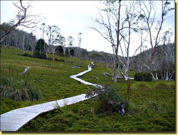
Cradle Valley Boardwalk
The Dove Lake Circuit, followed by the Lake Lilla Walk and then the Cradle Valley walk totalled some 14 Km and was considered enough walking for that one day. We drove back to Rosebery, had dinner, and despite the odd railway rumble, slept soundly.
Day 18:
The walk to Montezuma Falls starts at
the car park just past the old township of
Williamsford, which is approximately seven kilometres south of
Rosebery. It is an easy walk, taking around three hours return.
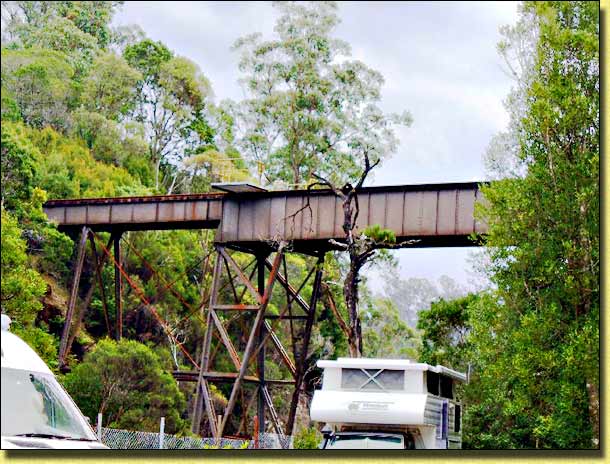
The history of the track itself is every bit as interesting as the falls.
The track follows the route of the historic North East Dundas Tramway, constructed during the 1890s, which linked smelters at Zeehan to mining operations in these hills. The hills are full of holes. Tin, lead, gold, silver and zinc were mined from hand dug audits into the hillside. The ore, once dug, was transported to Zeehan via the tramline. Every now and then we spotted the decaying remains of an old trestle bridge deep in the forest.
The narrow two-foot wide gauge (called a tramway) was chosen to suit the winding route and reduce the construction costs. From Williamsford, it is 15 Km to Zeehan as the crow flies. However, in order to maintain a suitable grade, the tramway's route is three times this distance. This means a lot of bends - about 60 in every two kilometres of line. As well as ore, the tramway carried passengers and firewood. At its peak, 700 tons of firewood was freighted to Zeehan smelters each week. Much of the finished product from the smelters was shipped to Germany for use in machinery and weapons.
All that remains of the North East Dundas Tramway
A 1908 guidebook to the area eloquently described Montezuma Falls as "One of the most picturesque sights in Western Tasmania. The spray splashes onto the passing train." A suspension bridge near the bottom of the falls now provides an opportunity to feel the spray spoken of so long ago! Having a 104 metre final drop (240 metres total drop in three stages), it is one of the highest waterfalls in Tasmania. The name of the falls appears to have come from the Mexican Montezuma Silver Company which operated a lease near there.
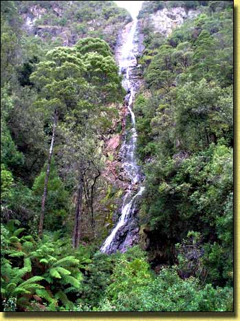
The 104 metre final drop of Montezuma Falls
Day 19:
After a wet night we had to pull down in the rain. Fortunately, the A'van
having solid sides means there is no wet
canvas to have to contend with... what a bonus! Our Sportliner
however, has a full width opening window fairly
high up on the front roof. This is where it needs to be as it
gives more headroom for washing the dishes at the sink, and also floods the
inside of the A'van with sunlight during the day. Being high up the roof
means we never need to draw the curtains on that window during the night.
The only disadvantage is when the A'van is closed up for travelling, that window
and the curtains are positioned over the top of
the rear roof. If the rear roof is wet, there is a possibility
the curtains would get wet and dirty. We have considered removing the
curtains, but that detracts from the "cosy" feeling we always have inside our
A'van. I have devised a method of wiping the rear roof dry after it is
partially closed, but it is a bit of a hassle. If the roof is wet, but
it is not actually raining at the time, then drying it off whilst it is still up
is easily achieved with a squeegee on the extendable pole that we always carry.
From Rosebery to Stanley is around 200 Km and it rained heavily all the way.
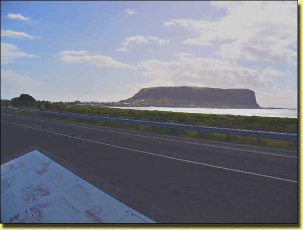
The "Nut" through the mist as we approach Stanley
It was still raining heavily as we booked in at Stanley Cabin and Tourist Park which nestles below "The Nut", and fronts Tatlow's Beach. Setting up in the rain is not a problem, and we were soon enjoying lunch, listening to the rain beating down on the roof. Inside the A'van, it always sounds as if it is raining heavier than it really is... but we both love to hear that sound!
When we last stayed at this park, it was part of the Big-4 chain. But not anymore apparently, and it shows! The amenities were spotless, each washbasin had a sponge to wipe down after use, there was liquid soap and paper towels. Each shower even had a towel floor mat (which was changed each day) for the drying area. All the roads throughout the park were hot mix bitumen sealed, which really does cut down on dust, particularly in a place like Stanley which is very exposed to on-shore winds. At $24.00 a night for two people on a powered site at what would be their peak period we thought was excellent value. The ample supply of "wheelie bins" were emptied every day and given a spray with a deodoriser. Pam contrasted that with what we observed when we last stayed at the "prodigious" Big-4 Parkgate Resort, Halls Gap in the Victorian Grampians. During our stay, the wheelie bins (which were bursting when we arrived) were not emptied at all. The only attention they received was a daily "jump on" from one of the staff. They were still bursting when we left, but were more tightly packed. We used to love staying at that park and have stayed there on many occasions before, but over the last couple of years, our experience of Big-4 parks is that prices have skyrocketed and the facilities have gone in the other direction. Speaking with other caravanners, we are obviously not the only ones having this opinion.
Being too wet to walk up "The Nut", we spent the afternoon walking around the very tidy town of Stanley.
Day 20:
Rain has stopped and the ever present
wind quickly dries out the place. We had been told that Allendale Gardens,
12 Km south of Smithton were well
worth a visit, so we decided to check them out and re-provision the larder from
Smithton.
We were not disappointed with the gardens. Since 1980, Loraine and Max Cross have together created "a place of beauty, peace and tranquillity." The gardens are spread over 6 acres and there are a further 65 acres of privately owned old growth rainforest. The combination of flower and foliage with trees and conifer indigenous to countries from around the world create a series of "garden rooms".
The entrance leads through Reception and the Tea Rooms. As we passed through, a CD of hauntingly beautiful flute music was playing in the background, which really set the scene for what was to come. We were given a brochure with a colourful map suggesting a route through the whole garden, and by following this we felt we didn't miss anything, yet were not having to retrace our steps. Whilst difficult to believe, the whole of the garden was created from a grassed field since 1980 when the first trees were planted. There are so many parts to the garden it would be difficult to do them justice here, so we refer you to their website www.allendalegardens.com.au for further insight.
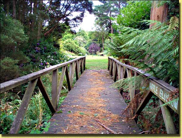
Bridge of the Apple Blossom, Allendale Gardens
The path from the gardens leads into Allendale's own 65 acre "Cool Temperate Rainforest". The "magical" half hour forest walk includes a "big tree" grove, ferns and a "fairy glade". This poem by Phil Rush says it all:
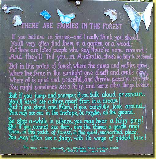
"Interpretive Sign" in the Fairy Glades, Allendale Gardens
The way out passed through the Tea Rooms, where Loraine served her home made jams and scones Devonshire Teas... the perfect ending to a most enjoyable visit!
Day 21:
"The Nut" beckons! You can pay $10 each and take the "chairlift" or you can be cheapskates like us and walk up.
There is no seniors or any other sort of concession on the chairlift.
The path up is well-paved but steep in places. Views from the top
of this spectacular outcrop include the north
coast and the historic town of Stanley, far below. Parks and Wildlife have installed
interpretive signage around the summit.
Almost surrounded by ocean, the Nut rises 152 metres abruptly from Bass Strait. In 1798, Matthew Flinders compared it to a Christmas cake! Currently it is a Tasmanian State Reserve, having previously been used for postal, telegraphic and telephonic services under the Commonwealth Government.
Migrating birds such as the Short-tailed Shearwater (Mutton Bird), Nankeen Kestrels, Peregrine Falcons, Silver Gulls, Orange-bellied Parrots and Black-eared Cuckoos have all been known to visit the Nut. Not surprisingly, these do not use the chairlift either!
All this gave us a good appetite for lunch, after which we explored "Old Stanley Burial Ground". It seems that in the early days of the settlement, if you survived into adulthood, there was a good chance you would live to a "ripe old age". A large number of the people buried in the cemetery in the 1800s seem to have lived for as long as we do now. No doubt the advertised "World's cleanest water and freshest air" would have helped!
From there we walked up to Historic Highfield, built in 1834 and originally headquarters of the Van Diemen's Land Company. The property is open for viewing as a self-guided tour. On arrival, a guide gave us an introduction to the site, and a floor/site plan of the property. There were various interpretive signs throughout the homestead telling the story of Highfield and its past occupants. Well worth the few hours we spent there.
Stanley from Highfield
A further walk around the town confirmed Stanley to be one of the neatest, tidiest towns we have seen in all our travels, anywhere in Australia. Little wonder it is has been voted Tasmania's Tidiest Town on so many occasions, and in 1996 even Australia's Tidiest Town.
Stanley Marine Park & Lighthouse
Typical cottage on Alexander Terrace
Day 22:
It was with some sadness that we pulled down this morning for the last time in
Tasmania... or for some time at least. Our ship sails from Devonport for
the "other island" this evening at
9:00 pm and we need to be on it. Devonport is just 140 Km from Stanley,
but we need to be off our site at the caravan park by 10:00 am. The
weather is fine, but being Stanley, there is
always a fresh breeze... sometimes a very fresh breeze! Some
friends who also have an A'van found it necessary when staying here, to move
their A'van whilst still up to a sheltered spot before pulling down. In
high winds, there is always the possibility that once the sides are folded in,
a wind gust could get under the open roof sections and fling them right out...
not a pretty sight! We have no
such problems today however.
Our journey takes us along the Bass Highway through Wynyard and Somerset to Burnie, where we stop for lunch. Burnie Park, on the right as you enter Burnie, looks attractive from the road and we soon find a picnic spot with a good view looking over the Civic Centre Precinct and out to Bass Strait. After lunch, having plenty of time left, we follow a marked track along Shorewell Creek up to Oladker Falls which was well worth the effort and took care of another hour or so.
From Burnie, we took the minor coastal road which passed through the townships of Penguin, Ulverstone and Turners Beach. This was a pleasant drive, quiet and picturesque, having just the meandering railway line between the road and the ocean. We arrived in Devonport at 4:00 pm. Once again, there was no sign of "The Spirit" waiting for us at the quay. Being a weekend, and it still being the "peak tourist period", it hadn't arrived yet from the daytime crossing. Not to worry (we thought) it will be here by 6:00 pm and we will be enjoying our evening meal in the "Waves Eatery" by 8:00 pm (or so we thought).
We filled up with petrol and then parked on Victoria Parade which runs alongside the Mersey River. We then walked across Bluff Beach onto the Mersey Bluff Reserve to check out the Mersey Bluff Caravan Park. From our casual observation, it seemed somewhat disorganised, there being campers scattered all over the place! The amenities were open and appeared "adequate".
Back to the car, and by 6:30 pm we had joined the queue of caravans and motorhomes waiting to board by the 7:30 pm boarding time. Ominously, there was no sign of the fair "Spirit". "Here she comes!" exclaims Pam, by which time it was nearly 7:30 pm. It was 9:30 pm by the time the queue started to move, and well past 10:00 pm by the time we were seated in the "Waves Eatery". Some time later, there was movement... and we were on our way. The Captain's voice came over the public address system, apologised for the delay, due entirely to "Port Operations"... end of!
Day 23:
As we were running late, we did not have to get up so early. The alarm
was set for 6:30 am which gave us plenty of time for a shower and breakfast
before we arrived at Station Pier in
Melbourne at around 7:15 am. Then, the usual rush to get off which went
quite smoothly, and we were on the road on our way to
Holbrook
Motor Village where we planned to stopover for the night. We arrived
at Holbrook at 2:00 pm, only to be told that they couldn't book us in as the
whole district was without electricity. "Go
and select a site, and we will book you in when it comes back on".
That sounded fair enough so we set up on the grassiest site we could find, and
rummaged around for the old tin kettle, which we hadn't needed to use since April
2000. Fortunately, the power then came on so the kettle was returned from
whence it came.
When we went to book in, in addition to our Top Tourist Membership discount, we were given an additional discount to compensate for being without power for the 90 minutes! The remainder of the afternoon was spent on that favourite of caravanning pastimes... yarning with neighbours!
Day 24:
A beautiful day for travelling. After "pull down" we were on the road by
9:00 am, and following an uneventful journey, we are home by lunch time.
Three weeks after leaving home, Pam's garden looked just as healthy as when we left, despite our only having
had 6 mm of rainfall during that period. Fortunately, a good neighbour kept water up to the plants, within the
constraints of our Stage 3 Water
Restrictions, which seem to have been in force for ever.
That will be the last time we go to Tasmania, she said...
but that is what was said before, and the time before that, and on neither
occasion did we regret the change of mind!
Statistics:
Summary:
To experience the most Tasmania has to offer, enjoying walking would be a big plus. There are so
many walks, graded from easy, to moderate, to difficult. If day walks
are what interests you, the booklet "Tasmania's
60 Great Short Walks" will tell you all you need to know and is
freely available from most of the Visitor Centres.
What we particularly noticed on this trip was that everybody (except us) seemed to think they needed a bigger and better caravan or motorhome. Campervans (the ubiquitous VW Combi in some outrageous colour being a particular favourite!) have been replaced by large mobile homes, and caravans having just one axle are becoming an endangered species. A double axle now seems to be a "must have"! Even worse, those terrible "5th wheelers" are monsters, and travelling in them must be such a hassle. All these have showers and toilets of course, but it is significant that the owners still seem to use the caravan park amenities block or an en-suite site when they realise the showers and toilets in their own van have to be cleaned out (just like at home), and the "black water" dumped somewhere!
Meanwhile, ten years after buying our A'van, we have yet to see anything (regardless of price) which would better suit our needs when on holiday in our climate. It has the advantages of a solid wall caravan - solid sides (no canvas, which makes heating or cooling difficult and ghastly to have to pack away when wet) yet also has the advantages of a relatively small trailer for towing, moving around on site and storing when at home. Like a caravan, once set up on site, you still have the tow vehicle for exploring the surrounding area or getting that loaf of bread when the corner shop is too far from the camp ground to walk to or cycle. With a motorhome (and particularly a large one), to get around everything has to be packed up again, and when you return you could well find someone has nicked your "prime" site and all that is left is that one adjacent to the toilet block with zero outlook, other than incontinent campers streaming by throughout the night!
Our plan to catch and leave "The Spirit" in Melbourne at the weekend, as the traffic on the approach would be lighter, did have a negative. At the time of year we travelled, "The Spirit" makes both a night and a day crossing over the weekend. This gives the ship just three hours to turn around in port. If there are no problems, this would probably be sufficient. However, delays add up, which could mean the ship is running quite late by the end of the weekend... euphemistically described as "Port Operations"!
Keith & Pam Thomas
(April 2009)
E-mail: emrysthomas2024@gmail.com
Footnote (12/04/09):
We have since been asked if we found it necessary to book ahead at the caravan parks.
Before leaving, we did book a couple of nights stay at the first one (Low Head) as we were unsure when we would actually arrive there. As it turned out, we needn't have, as it is a large park and Low Head (or George Town) would not be regarded as the busiest of places. From then on, we did phone through a couple of days before, once we had chosen where we wanted to stay. For the busy parks (St Helens, Coles Bay, New Norfolk and Stanley) this proved to be a wise move as those parks were in fact full each night (or appeared to be), and we subsequently did come across caravanners who had tried to book the day before and were unable to get in. For the other parks we stayed at (Tarraleah, Rosebery and Holbrook), booking ahead at that time of year was not necessary.
Obviously, it would depend on the time of year and whether it was during school
holidays, but from our experience we would suggest phoning a couple of days ahead should be sufficient.
Website URL "actavanning.org/index.html"